Geolocate

Quezon topographic map

Click on the map to display elevation.

About this map

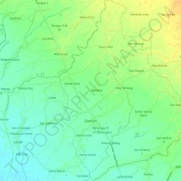
Name: Quezon topographic map, elevation, terrain.

Location: Quezon, Nueva Ecija, Central Luzon, 3113, Philippines (15.51580 120.78994 15.62856 120.87704)

Average elevation: 28 m

Minimum elevation: 18 m

Maximum elevation: 44 m

Other topographic maps

Click on a map to view its topography, its elevation and its terrain.

Cabanatuan

Philippines > Nueva Ecija

Average elevation: 47 m

Abar 1st

Philippines > Nueva Ecija

Average elevation: 105 m

Ciudad de Real

Philippines > Nueva Ecija > Cabanatuan

Average elevation: 36 m

Gapan

Philippines > Nueva Ecija

Average elevation: 34 m

Gear up for your next adventure:

🚲Bike Repair Kit - Essential tools for on-trail mechanical issues
🥾Waterproof Trail Shoes - Shoes designed to handle wet terrain
🧳Compression Sacks - Maximize space in your backpack by shrinking gear
🧴Waterproofing Spray - Restore the DWR coating on jackets and tents
🧥Softshell Jacket - Windproof and breathable jacket for hiking

As an Amazon Associate, this site earns from qualifying purchases at no extra cost to you.