Geolocate

Plympton topographic map

Click on the map to display elevation.

About this map
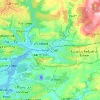
Name: Plympton topographic map, elevation, terrain.

Location: Plympton, Plymouth, England, PL7 4PE, United Kingdom (50.34982 -4.09857 50.42982 -4.01857)

Average elevation: 70 m

Minimum elevation: -38 m

Maximum elevation: 239 m

Other topographic maps

Click on a map to view its topography, its elevation and its terrain.
Plymouth Hoe

United Kingdom > England > Plymouth

Average elevation: 12 m

Mutley Park

United Kingdom > England > Plymouth

Average elevation: 54 m

Hooe Lake

United Kingdom > England > Plymouth

Average elevation: 25 m

Cann Woods

United Kingdom > England > Plymouth

Average elevation: 57 m

Devonport Park

United Kingdom > England > Plymouth

Average elevation: 15 m

Central Park

United Kingdom > England > Plymouth > Crownhill

Average elevation: 49 m

Beaumont Park

United Kingdom > England > Plymouth

Average elevation: 24 m

Whitleigh Wood

United Kingdom > England > Plymouth > Crownhill

Average elevation: 69 m

Gear up for your next adventure:

🥾Trail Hiking Shoes - Durable shoes designed for rugged trails
🔋Solar Power Bank - Keep your GPS and devices charged during long outdoor trips
💧Reusable Water Bottle - Durable water bottles for hydration on trails
🔋Lithium AA Batteries - Long-lasting power that performs in extreme cold
🔋Emergency Crank Radio - Weather alerts and power without needing batteries

As an Amazon Associate, this site earns from qualifying purchases at no extra cost to you.