
Bulawayo Province topographic map
Interactive map
Click on the map to display elevation.
About this map
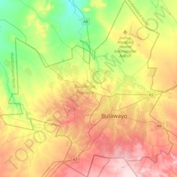
Name: Bulawayo Province topographic map, elevation, terrain.
Location: Bulawayo Province, Zimbabwe (-20.26059 28.38233 -19.95956 28.69483)
Average elevation: 1,321 m
Minimum elevation: 1,189 m
Maximum elevation: 1,477 m
Due to its relatively high altitude, the city has a humid subtropical climate despite lying in the tropics. Under the Köppen climate classification, Bulawayo features a semiarid climate (BSh). The mean annual temperature is 19.16 °C (66.49 °F), similar to Pretoria at a similar altitude but almost 600 km (373 mi) further south. As with much of southern and eastern Zimbabwe, Bulawayo is cooled by a prevailing southeasterly airflow most of the year and experiences three broad seasons: a dry, cool winter season from May to August; a hot dry period in early summer from late August to early November; and a warm wet period in the rest of the summer, early November to April.
Other topographic maps
Click on a map to view its topography, its elevation and its terrain.
Uzumba-Maramba-Pfungwe
Zimbabwe > Mashonaland East Province
Uzumba-Maramba-Pfungwe, Mashonaland East Province, Zimbabwe
Average elevation: 931 m
Hwange
Zimbabwe > Matabeleland North Province > Hwange
Hwange, Matabeleland North Province, Zimbabwe
Average elevation: 774 m
Gwanda
Zimbabwe > Matabeleland South Province > Gwanda > Gwanda
Gwanda, Matabeleland South Province, Zimbabwe
Average elevation: 1,012 m
Hwange
Zimbabwe > Matabeleland North > Hwange
Hwange, Matabeleland North, 00236, Zimbabwe
Average elevation: 968 m
Wedza
Zimbabwe > Mashonaland East Province
Wedza, Mashonaland East Province, Zimbabwe
Average elevation: 1,274 m
Lake Chivero
Lake Chivero, Kamba Caravan Park Acces Road, Zvimba, Mashonaland West, Zimbabwe
Average elevation: 1,382 m
Mount Nyangani
Mount Nyangani, Nyanga, Manicaland, Zimbabwe
Average elevation: 2,329 m
Centenary
Zimbabwe > Mashonaland Central > Centenary
Centenary, Muzarabani, Mashonaland Central, Zimbabwe
Average elevation: 1,199 m