
Matabeleland North Province topographic map
Interactive map
Click on the map to display elevation.
About this map
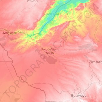
Name: Matabeleland North Province topographic map, elevation, terrain.
Location: Matabeleland North Province, Zimbabwe (-20.35534 25.23730 -16.86604 29.23332)
Average elevation: 1,014 m
Minimum elevation: 481 m
Maximum elevation: 1,553 m
Other topographic maps
Click on a map to view its topography, its elevation and its terrain.
Uzumba-Maramba-Pfungwe
Zimbabwe > Mashonaland East Province
Uzumba-Maramba-Pfungwe, Mashonaland East Province, Zimbabwe
Average elevation: 931 m
Hwange
Zimbabwe > Matabeleland North Province > Hwange
Hwange, Matabeleland North Province, Zimbabwe
Average elevation: 774 m
Gwanda
Zimbabwe > Matabeleland South Province > Gwanda > Gwanda
Gwanda, Matabeleland South Province, Zimbabwe
Average elevation: 1,012 m
Hwange
Zimbabwe > Matabeleland North > Hwange
Hwange, Matabeleland North, 00236, Zimbabwe
Average elevation: 968 m
Wedza
Zimbabwe > Mashonaland East Province
Wedza, Mashonaland East Province, Zimbabwe
Average elevation: 1,274 m
Lake Chivero
Lake Chivero, Kamba Caravan Park Acces Road, Zvimba, Mashonaland West, Zimbabwe
Average elevation: 1,382 m
Mount Nyangani
Mount Nyangani, Nyanga, Manicaland, Zimbabwe
Average elevation: 2,329 m
Centenary
Zimbabwe > Mashonaland Central > Centenary
Centenary, Muzarabani, Mashonaland Central, Zimbabwe
Average elevation: 1,199 m