
Make a donation
Gear up for your next adventure:
As an Amazon Associate, this site earns from qualifying purchases at no extra cost to you.
Mashonaland Central Province topographic map
Click on the map to display elevation.
Make a donation
Gear up for your next adventure:
As an Amazon Associate, this site earns from qualifying purchases at no extra cost to you.
About this map
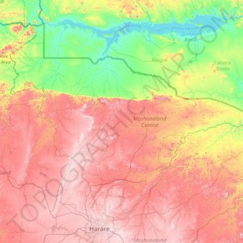
Name: Mashonaland Central Province topographic map, elevation, terrain.
Location: Mashonaland Central Province, Zimbabwe (-17.74197 30.04074 -15.62092 32.76116)
Average elevation: 859 m
Minimum elevation: 314 m
Maximum elevation: 1,724 m
Make a donation
Gear up for your next adventure:
As an Amazon Associate, this site earns from qualifying purchases at no extra cost to you.
Other topographic maps
Click on a map to view its topography, its elevation and its terrain.
Harare
The city proper has an area of 982.3km2 (378.7 mi2), a population of 1,849,600 as of the 2022 census and an estimated 2,487,209 people in its metropolitan province. The city is situated in north-eastern Zimbabwe in the country's Mashonaland region. Harare is a metropolitan province, which also incorporates the…
Average elevation: 1,470 m
Gwanda
Zimbabwe > Matabeleland South Province > Gwanda > Gwanda
The town is located 134 kilometres (83 mi), by road, south east of the city of Bulawayo, Zimbabwe's second largest city. This location lies on the Bulawayo–Beitbridge Road and the Beitbridge Bulawayo Railway. The town of Beitbridge, at Zimbabwe's border with the Republic of South Africa, lies approximately…
Average elevation: 1,012 m
Hwange
Zimbabwe > Matabeleland North Province > Hwange
Hwange (formerly Wankie) is a town in Zimbabwe, located in Hwange District, in Matabeleland North Province, in northwestern Zimbabwe, close to the international borders with Botswana and Zambia. It lies approximately 100 kilometres (62 mi), by road, southeast of Victoria Falls, the nearest large city. The town…
Average elevation: 774 m
Make a donation
Gear up for your next adventure:
As an Amazon Associate, this site earns from qualifying purchases at no extra cost to you.