Geolocate

Yuma topographic map

Click on the map to display elevation.

About this map

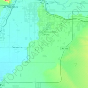
Name: Yuma topographic map, elevation, terrain.

Location: Yuma, Yuma County, Arizona, United States (32.47907 -114.68499 32.73229 -114.45913)

Average elevation: 56 m

Minimum elevation: 26 m

Maximum elevation: 254 m

Other topographic maps

Click on a map to view its topography, its elevation and its terrain.

Yuma

United States > Arizona > Yuma County

Average elevation: 69 m

Fortuna Foothills

United States > Arizona > Yuma County

Average elevation: 113 m

Buckshot

United States > Arizona > Yuma County

Average elevation: 52 m

Dateland

United States > Arizona > Yuma County

Average elevation: 134 m

Kofa

United States > Arizona > Yuma County

Average elevation: 118 m

Fortuna Foothills

United States > Arizona > Yuma County

Average elevation: 113 m

Roll

United States > Arizona > Yuma County

Average elevation: 80 m

Dateland

United States > Arizona > Yuma County

Average elevation: 134 m

Tyson

United States > Arizona > Yuma County

Average elevation: 94 m

Buckshot

United States > Arizona > Yuma County

Average elevation: 52 m

Gear up for your next adventure:

🛰️Satellite Messenger - Emergency communication for areas with no cell service
Bushcraft Tarp - Versatile emergency shelter or gear protection
🥾Approach Boots - Comfortable boots for hiking and climbing approaches
🥫Freeze-Dried Meals - Lightweight, high-calorie nutrition for multi-day treks
💡Compact LED Flashlight - Powerful and portable flashlight for outdoor use

As an Amazon Associate, this site earns from qualifying purchases at no extra cost to you.