Geolocate

Denice topographic map

Click on the map to display elevation.

About this map

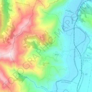
Name: Denice topographic map, elevation, terrain.

Location: Denice, Alessandria, Piedmont, Italy (44.58771 8.31398 44.62311 8.35486)

Average elevation: 353 m

Minimum elevation: 179 m

Maximum elevation: 652 m

Other topographic maps

Click on a map to view its topography, its elevation and its terrain.

Po

Italy > Piedmont > Alessandria > Coniolo

Average elevation: 146 m

Rosingo

Italy > Piedmont > Alessandria > Cerrina Monferrato

Average elevation: 234 m

Valle Scura

Italy > Piedmont > Alessandria > Brignano-Frascata

Average elevation: 396 m

Molini

Italy > Piedmont > Alessandria > Fraconalto

Average elevation: 624 m

Zanco

Italy > Piedmont > Alessandria > Villadeati

Average elevation: 241 m

Ciglione

Italy > Piedmont > Alessandria > Ponzone

Average elevation: 387 m

Gnocchetto

Italy > Piedmont > Alessandria > Ovada

Average elevation: 427 m

Mandrogne

Italy > Piedmont > Alessandria > Alessandria

Average elevation: 120 m

Incisa

Italy > Piedmont > Alessandria > Montacuto

Average elevation: 533 m

Gear up for your next adventure:

🛰️Satellite Messenger - Emergency communication for areas with no cell service
❄️Traction Ice Cleats - Slip-on spikes for icy trails and winter hiking
🔥Camping Stove - Portable stoves to cook outdoors with ease
🧥Thermal Fleece Jacket - Versatile insulation for changing mountain temperatures
🥾All-Terrain Hiking Boots - Versatile boots for varied hiking conditions

As an Amazon Associate, this site earns from qualifying purchases at no extra cost to you.