Geolocate

Incisa topographic map

Click on the map to display elevation.

About this map

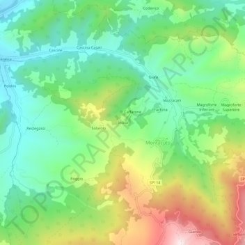
Name: Incisa topographic map, elevation, terrain.

Location: Incisa, Montacuto, Alessandria, Piedmont, 15056, Italy (44.74975 9.07687 44.78975 9.11687)

Average elevation: 533 m

Minimum elevation: 333 m

Maximum elevation: 898 m

Gear up for your next adventure:

🧢Hiking Hat - Sun-protective and breathable hats for long treks
🥾Hiking Shoes - Durable and comfortable shoes for trail hiking
🥾Mountaineering Boots - Supportive boots for climbing and high-altitude hiking
🔦LED Headtorch - Bright and durable light for night activities
🚲Heavy Duty Bike Lock - Secure your bike at the trailhead or during stops

As an Amazon Associate, this site earns from qualifying purchases at no extra cost to you.