
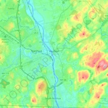
Hudson topographic map
Interactive map
Click on the map to display elevation.
About this map
Name: Hudson topographic map, elevation, terrain.
Average elevation: 68 m
Minimum elevation: 27 m
Maximum elevation: 172 m
Other topographic maps
Click on a map to view its topography, its elevation and its terrain.
Litchfield
United States > New Hampshire > Hillsborough County
Litchfield, Hillsborough County, New Hampshire, 03052, United States
Average elevation: 67 m
New Ipswich
United States > New Hampshire > Hillsborough County
New Ipswich, Hillsborough County, New Hampshire, 03071, United States
Average elevation: 339 m
West Peterborough
United States > New Hampshire > Hillsborough County > Peterborough
West Peterborough, Peterborough, Hillsborough County, New Hampshire, 03468, United States
Average elevation: 299 m
Hollis
United States > New Hampshire > Hillsborough County > Hollis
Hollis, Hillsborough County, New Hampshire, United States
Average elevation: 101 m
Manchester
United States > New Hampshire > Hillsborough County > Manchester
Manchester, Hillsborough County, New Hampshire, 03108, United States
Average elevation: 126 m
Goffstown
United States > New Hampshire > Hillsborough County > Goffstown
Goffstown, Hillsborough County, New Hampshire, 03045, United States
Average elevation: 159 m
Nashua
United States > New Hampshire > Hillsborough County
Nashua, Hillsborough County, New Hampshire, United States
Average elevation: 62 m