
Make a donation
Gear up for your next adventure:
As an Amazon Associate, this site earns from qualifying purchases at no extra cost to you.
Goffstown topographic map
Click on the map to display elevation.
Make a donation
Gear up for your next adventure:
As an Amazon Associate, this site earns from qualifying purchases at no extra cost to you.
Goffstown
The surface is comparatively level, the only elevations of note being two in the southwest part, called by the natives Uncanoonuck. There are considerable tracts of valuable interval, as well as extensive plains, which are generally productive. Piscataquog river is the principal stream, which furnishes quite a number of valuable mill privileges. It passes through in a central direction. Large quantities of lumber were formerly floated down this stream to the Merrimack, and the forests at one time supplied a large number of masts for the English navy. The New Hampshire Central Railroad passes through Goffstown. Then; are three villages — Goffstown, Goffstown Centre, and Parker's Mills; three church edifices — Baptist, Congregational, and Methodist; sixteen school districts; and two post-offices — Goffstown and Goffstown Centre: also, four stores, four saw-mills, two grist-mills, and one sash and blind factory. Population, 2,270; valuation, $599,615.
Make a donation
Gear up for your next adventure:
As an Amazon Associate, this site earns from qualifying purchases at no extra cost to you.
About this map
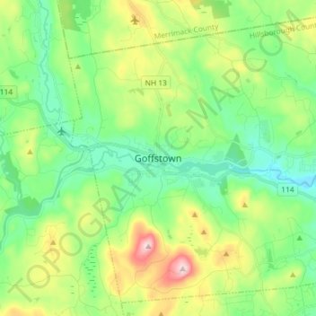
Name: Goffstown topographic map, elevation, terrain.
Average elevation: 159 m
Minimum elevation: 49 m
Maximum elevation: 402 m
Make a donation
Gear up for your next adventure:
As an Amazon Associate, this site earns from qualifying purchases at no extra cost to you.