
New Ipswich topographic map
Interactive map
Click on the map to display elevation.
About this map
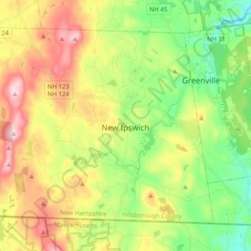
Name: New Ipswich topographic map, elevation, terrain.
Average elevation: 339 m
Minimum elevation: 180 m
Maximum elevation: 566 m
According to the United States Census Bureau, the town has a total area of 33.1 square miles (85.6 km2), of which 32.7 square miles (84.8 km2) are land and 0.3 square miles (0.8 km2) are water, comprising 0.97% of the town. The east and central parts of New Ipswich are drained by the Souhegan River, a northeast-flowing tributary of the Merrimack River. New Ipswich Mountain, part of the Wapack Range, is the highest point in the town, with an elevation of 1,881 feet (573 m) above sea level. On the west side of the Wapack Range, the northwest corner of town is drained by the Gridley River, a northwest-flowing tributary of the Contoocook River, which continues north to the Merrimack. The southwest part of town, including Mountain Pond, Island Pond, and Binney Pond, comprise headwaters of the Millers River, which flows southwest into Massachusetts, part of the Connecticut River watershed.
Other topographic maps
Click on a map to view its topography, its elevation and its terrain.
Litchfield
United States > New Hampshire > Hillsborough County
Litchfield, Hillsborough County, New Hampshire, 03052, United States
Average elevation: 67 m
West Peterborough
United States > New Hampshire > Hillsborough County > Peterborough
West Peterborough, Peterborough, Hillsborough County, New Hampshire, 03468, United States
Average elevation: 299 m
Hudson
United States > New Hampshire > Hillsborough County
Hudson, Hillsborough County, New Hampshire, 03051, United States
Average elevation: 68 m
Hollis
United States > New Hampshire > Hillsborough County > Hollis
Hollis, Hillsborough County, New Hampshire, United States
Average elevation: 101 m
Manchester
United States > New Hampshire > Hillsborough County > Manchester
Manchester, Hillsborough County, New Hampshire, 03108, United States
Average elevation: 126 m
Goffstown
United States > New Hampshire > Hillsborough County > Goffstown
Goffstown, Hillsborough County, New Hampshire, 03045, United States
Average elevation: 159 m
Nashua
United States > New Hampshire > Hillsborough County
Nashua, Hillsborough County, New Hampshire, United States
Average elevation: 62 m