Geolocate

Ormiston topographic map

Click on the map to display elevation.

Ormiston

Ormiston is a village in East Lothian, Scotland, near Tranent, Humbie, Pencaitland and Cranston, located on the north bank of the River Tyne at an elevation of about 276 feet (84 m).

Wikipedia (CC-BY-SA 3.0)

About this map

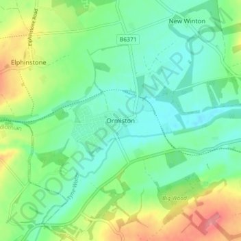
Name: Ormiston topographic map, elevation, terrain.

Location: Ormiston, East Lothian, Scotland, EH35 5HY, United Kingdom (55.89285 -2.95984 55.93285 -2.91984)

Average elevation: 102 m

Minimum elevation: 75 m

Maximum elevation: 159 m

Other topographic maps

Click on a map to view its topography, its elevation and its terrain.

Firth of Forth

United Kingdom > Scotland > East Lothian

Average elevation: 87 m

Lammermuirs

United Kingdom > Scotland > East Lothian

Average elevation: 266 m

Bass Rock

United Kingdom > Scotland > East Lothian

Average elevation: 0 m

Coldale Wood

United Kingdom > Scotland > East Lothian

Average elevation: 65 m

Gear up for your next adventure:

🔭Outdoor Binoculars - Lightweight binoculars for birdwatching and hiking
💡Portable Camping Lamp - Rechargeable lamp for campsite lighting
🧤Rechargeable Heated Gloves - Extreme warmth for Canadian winter expeditions
🥾Approach Boots - Comfortable boots for hiking and climbing approaches
🥾Waterproof Hiking Boots - Essential footwear for rugged terrain and wet Canadian trails

As an Amazon Associate, this site earns from qualifying purchases at no extra cost to you.