Geolocate

Kleven topographic map

Click on the map to display elevation.

About this map

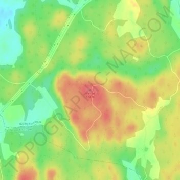
Name: Kleven topographic map, elevation, terrain.

Location: Kleven, Mjölby kommun, Östergötland County, 595 53, Sweden (58.27412 15.15218 58.27422 15.15228)

Average elevation: 140 m

Minimum elevation: 106 m

Maximum elevation: 172 m

Other topographic maps

Click on a map to view its topography, its elevation and its terrain.

Kinda kommun

Sweden > Östergötland County

Average elevation: 133 m

Navestad

Sweden > Östergötland County > Norrköping

Average elevation: 34 m

Vadstena

Sweden > Östergötland County

Average elevation: 98 m

Illern

Sweden > Östergötland County > Linköping

Average elevation: 72 m

Nässja

Sweden > Östergötland County

Average elevation: 91 m

Halgen

Sweden > Östergötland County

Average elevation: 88 m

Mjölby kommun

Sweden > Östergötland County

Average elevation: 123 m

Boxholms kommun

Sweden > Östergötland County

Average elevation: 169 m

Järstad

Sweden > Östergötland County

Average elevation: 82 m

Gear up for your next adventure:

🧭GPS Outdoor Watch - Smart watch for navigation and fitness tracking in nature
🦶Anti-Blister Balm - Prevents friction and hotspots during long ascents
👟Sport Hiking Sandals - Breathable footwear for water crossings and camp rest
🧢Sun Hat - Wide-brim hat for sun protection
🪜Heavy Duty Carabiners - Multi-use clips for securing gear to your backpack

As an Amazon Associate, this site earns from qualifying purchases at no extra cost to you.