Geolocate

Jiaxing topographic map

Click on the map to display elevation.

About this map

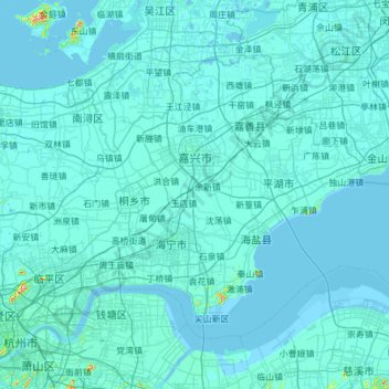
Name: Jiaxing topographic map, elevation, terrain.

Location: Jiaxing, Zhejiang, China (30.25749 120.29118 31.03243 121.50626)

Average elevation: 5 m

Minimum elevation: -7 m

Maximum elevation: 299 m

Other topographic maps

Click on a map to view its topography, its elevation and its terrain.

Lion mountain

China > Zhejiang > Hangzhou City

Average elevation: 15 m

甘山

China > Zhejiang > Chun'an County

Average elevation: 250 m

Chian

China > Zhejiang

Average elevation: 130 m

Gear up for your next adventure:

🧥Thermal Fleece Jacket - Versatile insulation for changing mountain temperatures
🚲MTB Frame Bag - Carry tools and maps directly on your bicycle frame
🪑Ultralight Camping Stool - Compact seating for rest stops during long hikes
🛶Kayak Accessories - Essential gear for safe and fun kayaking adventures
🧥Waterproof Jacket - Lightweight rain jackets for hiking and outdoor activities

As an Amazon Associate, this site earns from qualifying purchases at no extra cost to you.