Geolocate

St Kilda topographic map

Click on the map to display elevation.

About this map

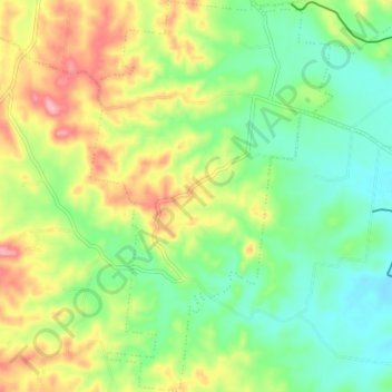
Name: St Kilda topographic map, elevation, terrain.

Location: St Kilda, Bundaberg Region, Queensland, 4671, Australia (-25.09810 151.89918 -25.03273 151.94380)

Average elevation: 86 m

Minimum elevation: 37 m

Maximum elevation: 163 m

Other topographic maps

Click on a map to view its topography, its elevation and its terrain.

Gin Gin

Australia > Queensland > Bundaberg Region > Gin Gin

Average elevation: 73 m

Isis River

Australia > Queensland > Bundaberg Region > Buxton

Average elevation: 12 m

Burrum River

Australia > Queensland > Bundaberg Region > Buxton

Average elevation: 20 m

Bundaberg

Australia > Queensland > Bundaberg Region

Average elevation: 18 m

Bundaberg

Australia > Queensland > Bundaberg Region

Average elevation: 18 m

Gear up for your next adventure:

Lightweight Camping Tent - Portable shelter optimized for Canadian backcountry camping
💡Compact LED Flashlight - Powerful and portable flashlight for outdoor use
💡LED Headlamp - Hands-free illumination for night hiking and camping
🧢Hiking Hat - Sun-protective and breathable hats for long treks
🥾Trail Hiking Boots - Supportive boots for rough trails

As an Amazon Associate, this site earns from qualifying purchases at no extra cost to you.