
Make a donation
Gear up for your next adventure:
As an Amazon Associate, this site earns from qualifying purchases at no extra cost to you.
Kuckberge topographic map
Click on the map to display elevation.
Make a donation
Gear up for your next adventure:
As an Amazon Associate, this site earns from qualifying purchases at no extra cost to you.
About this map
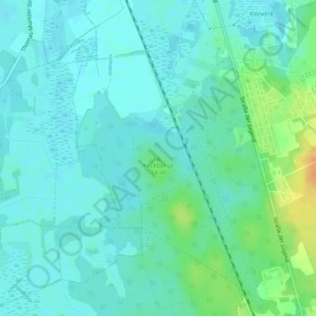
Name: Kuckberge topographic map, elevation, terrain.
Location: Kuckberge, Teltow-Fläming, Brandenburg, 15806, Deutschland (52.18687 13.44952 52.18697 13.44962)
Average elevation: 43 m
Minimum elevation: 35 m
Maximum elevation: 69 m
Make a donation
Gear up for your next adventure:
As an Amazon Associate, this site earns from qualifying purchases at no extra cost to you.
Other topographic maps
Click on a map to view its topography, its elevation and its terrain.
Trebbin
Deutschland > Brandenburg > Teltow-Fläming > Trebbin
sowie den Wohnplätzen: Ebelshof, Eichenhof, Finkenberg, Forsthaus Altlenzburg, Forsthaus Lenzburg, Freie-Scholle-Siedlung, Kolonie Thyrow, Paulshöhe, Plantage, Priedel, Schönblick, Seeblick und Ziegelei.
Average elevation: 42 m
Luckenwalde
Deutschland > Brandenburg > Teltow-Fläming
Luckenwalde liegt etwa 50 Kilometer südlich von Berlin, was durch den Merkspruch Luckenwalde, Luckenkien, 50 Kilometer vor Berlin. ausgedrückt wird. Nördlich von Luckenwalde liegt Trebbin, südlich Jüterbog, östlich Baruth/Mark und westlich Treuenbrietzen. In der Nähe des Marktturms beträgt die Höhe…
Average elevation: 55 m
Ludwigsfelde
Deutschland > Brandenburg > Teltow-Fläming
Die flachwellige, im Durchschnitt zehn bis zwanzig Meter mächtige Grundmoränenoberfläche des Teltow entstand vor rund 20.000 Jahren im Brandenburger Stadium der Weichseleiszeit. Die Höhenunterschiede zwischen dem Plateau und den glazialen Abflussbahnen spiegeln sich im unterschiedlichen Höhenniveau des…
Average elevation: 42 m
Make a donation
Gear up for your next adventure:
As an Amazon Associate, this site earns from qualifying purchases at no extra cost to you.