
Make a donation
Gear up for your next adventure:
As an Amazon Associate, this site earns from qualifying purchases at no extra cost to you.
Trebbin topographic map
Click on the map to display elevation.
Make a donation
Gear up for your next adventure:
As an Amazon Associate, this site earns from qualifying purchases at no extra cost to you.
Trebbin
sowie den Wohnplätzen: Ebelshof, Eichenhof, Finkenberg, Forsthaus Altlenzburg, Forsthaus Lenzburg, Freie-Scholle-Siedlung, Kolonie Thyrow, Paulshöhe, Plantage, Priedel, Schönblick, Seeblick und Ziegelei.
Make a donation
Gear up for your next adventure:
As an Amazon Associate, this site earns from qualifying purchases at no extra cost to you.
About this map
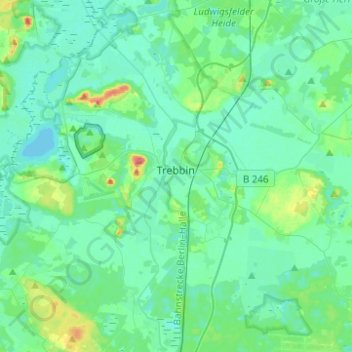
Name: Trebbin topographic map, elevation, terrain.
Location: Trebbin, Teltow-Fläming, Brandenburg, 14959, Deutschland (52.15153 13.08267 52.27319 13.33004)
Average elevation: 42 m
Minimum elevation: 30 m
Maximum elevation: 98 m
Make a donation
Gear up for your next adventure:
As an Amazon Associate, this site earns from qualifying purchases at no extra cost to you.
Other topographic maps
Click on a map to view its topography, its elevation and its terrain.
Klein Schulzendorf
Deutschland > Brandenburg > Teltow-Fläming > Trebbin > Klein Schulzendorf
Average elevation: 41 m