
Make a donation
Gear up for your next adventure:
As an Amazon Associate, this site earns from qualifying purchases at no extra cost to you.
Luckenwalde topographic map
Click on the map to display elevation.
Make a donation
Gear up for your next adventure:
As an Amazon Associate, this site earns from qualifying purchases at no extra cost to you.
Luckenwalde
Luckenwalde liegt etwa 50 Kilometer südlich von Berlin, was durch den Merkspruch Luckenwalde, Luckenkien, 50 Kilometer vor Berlin. ausgedrückt wird. Nördlich von Luckenwalde liegt Trebbin, südlich Jüterbog, östlich Baruth/Mark und westlich Treuenbrietzen. In der Nähe des Marktturms beträgt die Höhe über dem Meeresspiegel 49 Meter, bei den Weinbergen westlich des Stadtzentrums sind es 77 Meter.
Make a donation
Gear up for your next adventure:
As an Amazon Associate, this site earns from qualifying purchases at no extra cost to you.
About this map
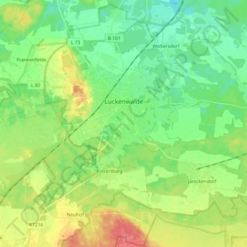
Name: Luckenwalde topographic map, elevation, terrain.
Location: Luckenwalde, Teltow-Fläming, Brandenburg, 14943, Deutschland (52.02684 13.08016 52.13402 13.21341)
Average elevation: 55 m
Minimum elevation: 34 m
Maximum elevation: 91 m
Make a donation
Gear up for your next adventure:
As an Amazon Associate, this site earns from qualifying purchases at no extra cost to you.
Other topographic maps
Click on a map to view its topography, its elevation and its terrain.
Klein Schulzendorf
Deutschland > Brandenburg > Teltow-Fläming > Trebbin > Klein Schulzendorf
Average elevation: 41 m