
Mulberry topographic map
Click on the map to display elevation.
About this map
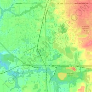
Name: Mulberry topographic map, elevation, terrain.
Location: Mulberry, Polk County, Florida, 22860, United States (27.88756 -82.03890 27.93835 -81.94182)
Average elevation: 45 m
Minimum elevation: 16 m
Maximum elevation: 88 m
Other topographic maps
Click on a map to view its topography, its elevation and its terrain.
Allen David Broussard Catfish Creek Preserve State Park
United States > Florida > Polk County
Average elevation: 18 m