Geolocate

Baar topographic map

Click on the map to display elevation.

About this map

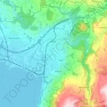
Name: Baar topographic map, elevation, terrain.

Location: Baar, Zug, Switzerland (47.15087 8.49602 47.22324 8.57775)

Average elevation: 534 m

Minimum elevation: 411 m

Maximum elevation: 928 m

Other topographic maps

Click on a map to view its topography, its elevation and its terrain.

Wildspitz

Switzerland > Zug > Unterägeri

Average elevation: 1,266 m

Zugerberg

Switzerland > Zug > Zug > Schönfels

Average elevation: 808 m

Edlibach

Switzerland > Zug

Average elevation: 693 m

Morgarten

Switzerland > Zug > Oberägeri

Average elevation: 892 m

Allenwinden

Switzerland > Zug > Baar

Average elevation: 730 m

Gottschalkenberg

Switzerland > Zug > Menzingen

Average elevation: 1,005 m

Gear up for your next adventure:

🥾Trail Running Shoes - Lightweight and durable shoes for trail running
Camping Groundsheet - Protect your tent from moisture and dirt
🛏️Camping Sleeping Mat - Comfortable mats for sleeping outdoors
🧤Thermal Hiking Gloves - Grip-enhanced gloves for cold-weather altitude trekking
🛶Canoe Life Vest - Safety vest for water sports

As an Amazon Associate, this site earns from qualifying purchases at no extra cost to you.