Geolocate

Copperas Cove topographic map

Click on the map to display elevation.

About this map

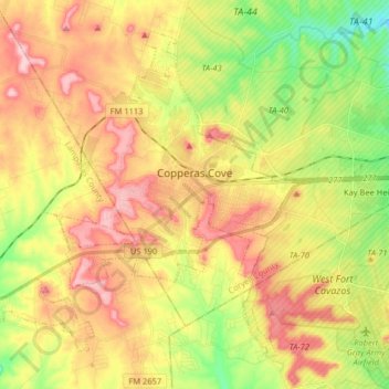
Name: Copperas Cove topographic map, elevation, terrain.

Location: Copperas Cove, Coryell County, Texas, 76522, United States (31.05817 -97.96623 31.17452 -97.80481)

Average elevation: 317 m

Minimum elevation: 231 m

Maximum elevation: 401 m

Other topographic maps

Click on a map to view its topography, its elevation and its terrain.

King Mountain

United States > Texas > Coryell County

Average elevation: 240 m

Purmela

United States > Texas > Coryell County

Average elevation: 321 m

Pidcoke

United States > Texas > Coryell County

Average elevation: 264 m

Cold Springs

United States > Texas > Coryell County

Average elevation: 250 m

Gear up for your next adventure:

🧰Survival Kit - Essential gear for emergencies in the wilderness
🥾Mountaineering Boots - Supportive boots for climbing and high-altitude hiking
🥾Hiking Shoes - Durable and comfortable shoes for trail hiking
🧢Sun Protection Cap - Breathable cap to protect from sun exposure
🥾Mountain Hiking Boots - High-traction boots for rocky terrain

As an Amazon Associate, this site earns from qualifying purchases at no extra cost to you.