Geolocate

Pidcoke topographic map

Click on the map to display elevation.

About this map

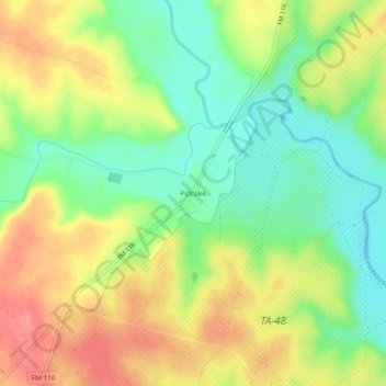
Name: Pidcoke topographic map, elevation, terrain.

Location: Pidcoke, Coryell County, Texas, United States (31.25906 -97.90836 31.29906 -97.86836)

Average elevation: 264 m

Minimum elevation: 225 m

Maximum elevation: 307 m

Other topographic maps

Click on a map to view its topography, its elevation and its terrain.

Copperas Cove

United States > Texas > Coryell County

Average elevation: 317 m

Gatesville

United States > Texas > Coryell County

Average elevation: 261 m

Oglesby

United States > Texas > Coryell County

Average elevation: 257 m

Copperas Cove

United States > Texas > Coryell County

Average elevation: 317 m

Evant

United States > Texas > Coryell County

Average elevation: 382 m

Gear up for your next adventure:

🥾Hiking Shoes - Durable and comfortable shoes for trail hiking
🛌Down Sleeping Bag - Superior warmth-to-weight ratio for cold nights
🎒Hiking Backpack - Lightweight and ergonomic backpacks for day hikes or multi-day treks
💧Hydration Bladder - Hands-free hydration solution for long treks
🛌Insulated Sleeping Pad - Critical thermal barrier between you and the cold ground

As an Amazon Associate, this site earns from qualifying purchases at no extra cost to you.