Geolocate

Mandai topographic map

Click on the map to display elevation.

About this map

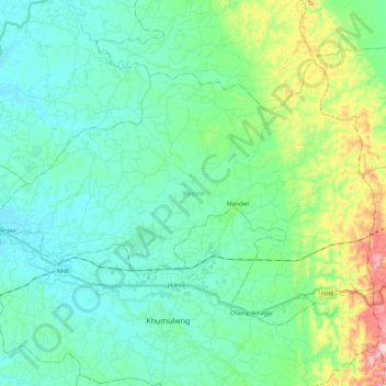
Name: Mandai topographic map, elevation, terrain.

Location: Mandai, West Tripura District, Tripura, India (23.79775 91.33816 23.93669 91.56049)

Average elevation: 64 m

Minimum elevation: 15 m

Maximum elevation: 238 m

Other topographic maps

Click on a map to view its topography, its elevation and its terrain.

Sabroom

India > Tripura > Satchand

Sabroom is located at 23°00′N 91°44′E / 23.00°N 91.73°E / 23.00; 91.73. It has an average elevation of 26 m (85 ft).

Average elevation: 29 m

Kanchanpur

India > Tripura > Dasda

Average elevation: 66 m

Teliamura

India > Tripura > Teliamura

Average elevation: 60 m

Kamalpur

India > Tripura > Durga Chowmuhani

Average elevation: 47 m

Bagafa

India > Tripura > Bokafa

Average elevation: 35 m

Gear up for your next adventure:

🥾Waterproof Hiking Shoes - Durable shoes for wet and rugged trails
🦟Insect Repellent - Keep mosquitoes and black flies away in wooded areas
🧤Rechargeable Heated Gloves - Extreme warmth for Canadian winter expeditions
🧴Bear Spray Holster - Quick-access carry for essential Canadian wilderness safety
Tent Footprint - Protect tent floor and increase durability

As an Amazon Associate, this site earns from qualifying purchases at no extra cost to you.