Geolocate

Sabroom topographic map

Click on the map to display elevation.

Sabroom

Sabroom is located at 23°00′N 91°44′E / 23.00°N 91.73°E / 23.00; 91.73. It has an average elevation of 26 m (85 ft).

Wikipedia (CC-BY-SA 3.0)

About this map

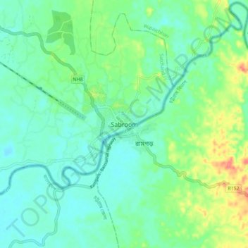
Name: Sabroom topographic map, elevation, terrain.

Location: Sabroom, Satchand, South Tripura, Tripura, 799145, India (22.96246 91.69070 23.04246 91.77070)

Average elevation: 29 m

Minimum elevation: 12 m

Maximum elevation: 71 m

Gear up for your next adventure:

🎒Hiking Daypack - Lightweight and durable backpacks for day trips and excursions
🏕️Camping Hammock - Integrated protection for sleeping between trees
🪜Heavy Duty Carabiners - Multi-use clips for securing gear to your backpack
🧭Orienteering Kit - Tools for map reading and navigation in the wild
🎒Fully Waterproof Backpack - Total protection for photography gear and electronics

As an Amazon Associate, this site earns from qualifying purchases at no extra cost to you.