Geolocate

Teliamura topographic map

Click on the map to display elevation.

About this map

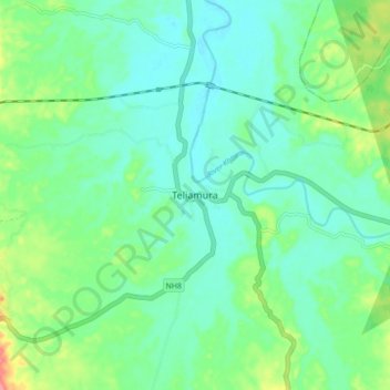
Name: Teliamura topographic map, elevation, terrain.

Location: Teliamura, Khowai District, Tripura, 799205, India (23.79982 91.58646 23.87982 91.66646)

Average elevation: 60 m

Minimum elevation: 39 m

Maximum elevation: 116 m

Gear up for your next adventure:

🥾Trekking Poles - Adjustable trekking poles to reduce knee stress and improve stability
💡LED Headlamp - Hands-free illumination for night hiking and camping
🧰Emergency Multi-Tool - Compact multi-tool for outdoor survival
🥾Mountain Hiking Shoes - Shoes with superior grip for mountainous terrain
🥾Trail Running Boots - Durable shoes designed for trail running

As an Amazon Associate, this site earns from qualifying purchases at no extra cost to you.