Geolocate

Boden topographic map

Click on the map to display elevation.

About this map

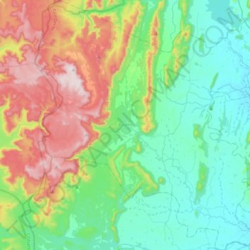
Name: Boden topographic map, elevation, terrain.

Location: Boden, Nuapada, Odisha, 766111, India (20.10351 82.39963 20.41775 82.70350)

Average elevation: 461 m

Minimum elevation: 229 m

Maximum elevation: 997 m

Other topographic maps

Click on a map to view its topography, its elevation and its terrain.

Bhainsadani

India > Odisha > Boden

Average elevation: 459 m

Ankapur

India > Odisha > Boden > Ankapur

Average elevation: 266 m

Gear up for your next adventure:

🔥Emergency Fire Starter - Reliable ignition source for all weather conditions
🧳Compression Sacks - Maximize space in your backpack by shrinking gear
🔦UV Flashlight - Detect minerals or specific insects in the dark
🧴Outdoor Sunscreen - High SPF protection for high-altitude UV exposure
🌡️Emergency Mylar Blankets - Compact thermal protection for unexpected nights outdoors

As an Amazon Associate, this site earns from qualifying purchases at no extra cost to you.