Geolocate

Bhainsadani topographic map

Click on the map to display elevation.

About this map

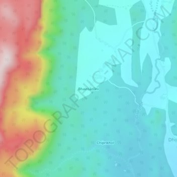
Name: Bhainsadani topographic map, elevation, terrain.

Location: Bhainsadani, Boden, Nuapada, Odisha, India (20.26391 82.48994 20.30391 82.52994)

Average elevation: 459 m

Minimum elevation: 322 m

Maximum elevation: 860 m

Other topographic maps

Click on a map to view its topography, its elevation and its terrain.

Boden

India > Odisha > Boden

Average elevation: 461 m

Gear up for your next adventure:

🥾Trekking Poles - Adjustable trekking poles to reduce knee stress and improve stability
🧤Thermal Hiking Gloves - Grip-enhanced gloves for cold-weather altitude trekking
🛶Canoe Life Vest - Safety vest for water sports
🦶Anti-Blister Balm - Prevents friction and hotspots during long ascents
🧥Softshell Jacket - Windproof and breathable jacket for hiking

As an Amazon Associate, this site earns from qualifying purchases at no extra cost to you.