Geolocate

Grundy topographic map

Click on the map to display elevation.

About this map
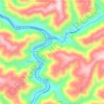
Name: Grundy topographic map, elevation, terrain.

Location: Grundy, Buchanan County, Virginia, 24614, United States (37.25350 -82.12691 37.29259 -82.07707)

Average elevation: 490 m

Minimum elevation: 310 m

Maximum elevation: 663 m

Other topographic maps

Click on a map to view its topography, its elevation and its terrain.
Oakwood

United States > Virginia > Buchanan County

Average elevation: 586 m

Page

United States > Virginia > Buchanan County

Average elevation: 596 m

Hurley

United States > Virginia > Buchanan County

Average elevation: 443 m

Hanger

United States > Virginia > Buchanan County > Oakwood

Average elevation: 581 m

Height

United States > Virginia > Buchanan County

Average elevation: 725 m

Height

United States > Virginia > Buchanan County

Average elevation: 725 m

Height

United States > Virginia > Buchanan County

Average elevation: 725 m

Height

United States > Virginia > Buchanan County

Average elevation: 725 m

Height

United States > Virginia > Buchanan County

Average elevation: 725 m

Gear up for your next adventure:

🚲Bike Repair Kit - Essential tools for on-trail mechanical issues
🛌Insulated Sleeping Pad - Critical thermal barrier between you and the cold ground
🥾Waterproof Hiking Boots - Essential footwear for rugged terrain and wet Canadian trails
🧊Portable Cooler - Keep food and drinks cold during outdoor adventures
🥾Hiking Shorts - Breathable shorts suitable for summer hikes

As an Amazon Associate, this site earns from qualifying purchases at no extra cost to you.