Geolocate

Height topographic map

Click on the map to display elevation.

About this map

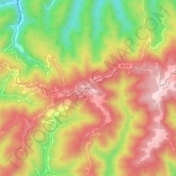
Name: Height topographic map, elevation, terrain.

Location: Height, Buchanan County, Virginia, 24850, United States (37.26067 -81.83400 37.30067 -81.79400)

Average elevation: 725 m

Minimum elevation: 495 m

Maximum elevation: 896 m

Other topographic maps

Click on a map to view its topography, its elevation and its terrain.

Grundy

United States > Virginia > Buchanan County

Average elevation: 490 m

Grundy

United States > Virginia > Buchanan County

Average elevation: 490 m

Vansant

United States > Virginia > Buchanan County > Vansant

Average elevation: 514 m

Grundy

United States > Virginia > Buchanan County

Average elevation: 490 m

Gear up for your next adventure:

🚑Survival Whistle - Signal for help across long distances in mountains
🛌Insulated Sleeping Pad - Critical thermal barrier between you and the cold ground
💧Hydration Bladder - Hands-free hydration solution for long treks
💧Hydration Pack - Hands-free hydration system for long hikes
🧦Hiking Socks - Moisture-wicking and comfortable socks for long hikes

As an Amazon Associate, this site earns from qualifying purchases at no extra cost to you.