Geolocate

Hurley topographic map

Click on the map to display elevation.

About this map

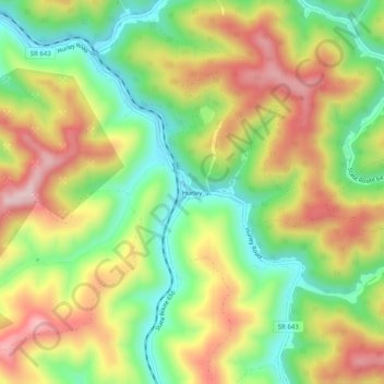
Name: Hurley topographic map, elevation, terrain.

Location: Hurley, Buchanan County, Virginia, 24620, United States (37.40039 -82.03985 37.44039 -81.99985)

Average elevation: 443 m

Minimum elevation: 282 m

Maximum elevation: 631 m

Other topographic maps

Click on a map to view its topography, its elevation and its terrain.

Grundy

United States > Virginia > Buchanan County

Average elevation: 490 m

Vansant

United States > Virginia > Buchanan County > Vansant

Average elevation: 514 m

Grundy

United States > Virginia > Buchanan County

Average elevation: 490 m

Grundy

United States > Virginia > Buchanan County

Average elevation: 490 m

Gear up for your next adventure:

🧤Insulated Winter Gloves - Heavy-duty protection for sub-zero Canadian adventures
🥾Light Trekking Boots - Supportive boots for multi-day treks
🥾Mountaineering Boots - Supportive boots for climbing and high-altitude hiking
🧴Bear Spray Holster - Quick-access carry for essential Canadian wilderness safety
🥾Hiking Boots - Sturdy boots providing ankle support and traction on rugged trails

As an Amazon Associate, this site earns from qualifying purchases at no extra cost to you.