
Amecameca topographic map
Interactive map
Click on the map to display elevation.
About this map
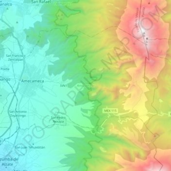
Name: Amecameca topographic map, elevation, terrain.
Location: Amecameca, State of Mexico, Mexico (19.05676 -98.81808 19.18319 -98.62549)
Average elevation: 3,197 m
Minimum elevation: 2,313 m
Maximum elevation: 5,218 m
The municipality is situated on the foothills of the Sierra Nevada between the Iztaccíhuatl and Popocatépetl and in the Moctezuma-Panuco River. The Sierra Nevada is the most important geographical feature of the region and forms the eastern border of the municipality. These volcanoes are responsible for the compositions of the soils here as well as the source of most of the municipality's fresh water. The average altitude in these mountains is 4,000 meters above sea level with the highest elevations at the Iztaccíhuatl and Popocatépetl volcanos. Although near the active volcano, Amecameca is considered to be at a lower risk than other communities in the area because of the shape of Popocatépetl's cone and the large ravines that are found in this area. The latter offers protection against lava flows and runoff from melting snow. However, the area remains part of the evacuation zone in the event of a major eruption. There is a lookout station on Sacromonte hill which is used by civil defense when the volcano is more active. The area has an eruption warning system of three colors—red, yellow and green—which depend on the status of Popocatepetl. Green means that the volcano is quiet, yellow that there is activity and caution is advised and red indicates a current or imminent eruption. When the status turns to yellow, tourism to the area plummets to about half normal.
Other topographic maps
Click on a map to view its topography, its elevation and its terrain.
Papalotla
Papalotla, State of Mexico, 56050, Mexico
Average elevation: 2,265 m
Texcoco de Mora
Mexico > State of Mexico > Texcoco
Texcoco de Mora, Texcoco, State of Mexico, 56100, Mexico
Average elevation: 2,448 m
Ciudad Satélite
Mexico > State of Mexico > Naucalpan de Juárez
Ciudad Satélite, Naucalpan de Juárez, State of Mexico, 53100, Mexico
Average elevation: 2,299 m
Nevado de Toluca
Mexico > State of Mexico > Toluca
Nevado de Toluca, Toluca, State of Mexico, Mexico
Average elevation: 4,271 m
Barrio la Cascada (Barrio del Varal)
Mexico > State of Mexico > Temascaltepec
Barrio la Cascada (Barrio del Varal), Temascaltepec, State of Mexico, Mexico
Average elevation: 1,872 m
Ciudad López Mateos
Mexico > State of Mexico > Atizapán de Zaragoza
Ciudad López Mateos, Atizapán de Zaragoza, State of Mexico, 52940, Mexico
Average elevation: 2,426 m
Interlomas
Mexico > State of Mexico > Huixquilucan
Interlomas, Huixquilucan, State of Mexico, 52760, Mexico
Average elevation: 2,656 m
Teotihuacán
Teotihuacán, State of Mexico, 55845, Mexico
Average elevation: 2,346 m
Valle de Bravo
Mexico > State of Mexico > Valle de Bravo
Valle de Bravo, State of Mexico, 51200, Mexico
Average elevation: 1,914 m
Ojo de Agua
Mexico > State of Mexico > Tecámac
Ojo de Agua, Tecámac, State of Mexico, 55770, Mexico
Average elevation: 2,297 m
Rancho San Dimas
Mexico > State of Mexico > San Antonio la Isla
Rancho San Dimas, San Antonio la Isla, State of Mexico, 52220, Mexico
Average elevation: 2,585 m
Tlalnepantla de Baz
Tlalnepantla de Baz, State of Mexico, Mexico
Average elevation: 2,323 m
Nezahualcóyotl
Nezahualcóyotl, State of Mexico, Mexico
Average elevation: 2,235 m
Cerro Prieto
Mexico > State of Mexico > Isidro Fabela
Cerro Prieto, Isidro Fabela, State of Mexico, 04830, Mexico
Average elevation: 3,415 m
Lerma de Villada
Mexico > State of Mexico > Lerma
Lerma de Villada, Lerma, State of Mexico, 52006, Mexico
Average elevation: 2,577 m
Endexhe
Mexico > State of Mexico > Lerma > Endexhe
Endexhe, Lerma, State of Mexico, 52050, Mexico
Average elevation: 2,740 m
Texcalyacac
Mexico > State of Mexico > Texcalyacac
Texcalyacac, State of Mexico, Mexico
Average elevation: 2,632 m
Cuautitlán
Mexico > State of Mexico > Cuautitlán
Cuautitlán, State of Mexico, Mexico
Average elevation: 2,258 m
Las Cruces
Las Cruces, Temascaltepec, State of Mexico, Mexico
Average elevation: 3,206 m
Monarch Butterfly Biosphere Reserve
Mexico > State of Mexico > Villa de Allende
Monarch Butterfly Biosphere Reserve, Villa de Allende, State of Mexico, Mexico
Average elevation: 2,461 m
Temascaltepec
Mexico > State of Mexico > Temascaltepec
Temascaltepec, State of Mexico, Mexico
Average elevation: 2,604 m
Jocotitlán
Mexico > State of Mexico > Jocotitlán
Jocotitlán, State of Mexico, Mexico
Average elevation: 2,674 m
Cacalomacan
Mexico > State of Mexico > Toluca > Cacalomacan
Cacalomacan, Toluca, State of Mexico, 50265, Mexico
Average elevation: 2,790 m
Tlalnepantla
Mexico > State of Mexico > Tlalnepantla de Baz
Tlalnepantla, Tlalnepantla de Baz, State of Mexico, 54000, Mexico
Average elevation: 2,358 m
Predio de los Albertocos
Mexico > State of Mexico > Temamatla > Temamatla > Predio de los Albertocos
Predio de los Albertocos, Temamatla, State of Mexico, Mexico
Average elevation: 2,313 m
Santa María Tulpetlac
Mexico > State of Mexico > Ecatepec de Morelos > Santa María Tulpetlac
Santa María Tulpetlac, Ecatepec de Morelos, State of Mexico, 55400, Mexico
Average elevation: 2,280 m
La Marquesa
Mexico > State of Mexico > La Marquesa
La Marquesa, Ocoyoacac, State of Mexico, 05750, Mexico
Average elevation: 3,138 m
San Franciso de Asís
San Franciso de Asís, State of Mexico, Mexico
Average elevation: 890 m
Huixquilucan
Mexico > State of Mexico > Huixquilucan
Huixquilucan, State of Mexico, Mexico
Average elevation: 2,921 m
Timilpan
Mexico > State of Mexico > Timilpan
Timilpan, State of Mexico, Mexico
Average elevation: 2,704 m
Santa Catarina
Mexico > State of Mexico > Lerma
Santa Catarina, Lerma, State of Mexico, 52055, Mexico
Average elevation: 2,602 m
Ozumba
Mexico > State of Mexico > Ozumba
Ozumba, State of Mexico, 56800, Mexico
Average elevation: 2,353 m
Zinacantepec
Mexico > State of Mexico > Zinacantepec
Zinacantepec, State of Mexico, Mexico
Average elevation: 3,103 m
Barrio Paraiso
Mexico > State of Mexico > Huixquilucan > Barrio Paraiso
Barrio Paraiso, Huixquilucan, State of Mexico, 52773, Mexico
Average elevation: 2,679 m
Trojes
Mexico > State of Mexico > Luvianos > Trojes
Trojes, Luvianos, State of Mexico, 51440, Mexico
Average elevation: 1,143 m
Teoloyucan
Mexico > State of Mexico > Teoloyucan
Teoloyucan, State of Mexico, Mexico
Average elevation: 2,253 m
Chapultepec
Mexico > State of Mexico > Chapultepec
Chapultepec, State of Mexico, Mexico
Average elevation: 2,587 m
Tequixquiac
Mexico > State of Mexico > Tequixquiac
Tequixquiac, State of Mexico, Mexico
Average elevation: 2,296 m
Naucalpan
Mexico > State of Mexico > Naucalpan de Juárez
Naucalpan, Naucalpan de Juárez, State of Mexico, 53370, Mexico
Average elevation: 2,459 m
Nevado de Toluca
Nevado de Toluca, Tenango del Valle, State of Mexico, Mexico
Average elevation: 4,037 m
Popocatépetl
Mexico > State of Mexico > Atlautla
Popocatépetl, Atlautla, State of Mexico, Mexico
Average elevation: 4,810 m