
Snailbeach topographic map
Interactive map
Click on the map to display elevation.
About this map
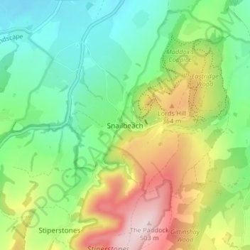
Name: Snailbeach topographic map, elevation, terrain.
Location: Snailbeach, Shropshire, England, SY5 0NX, United Kingdom (52.59381 -2.94663 52.63381 -2.90663)
Average elevation: 248 m
Minimum elevation: 105 m
Maximum elevation: 498 m
Other topographic maps
Click on a map to view its topography, its elevation and its terrain.
Ellesmere
United Kingdom > England > Shropshire
Ellesmere, Shropshire, England, SY12 0EQ, United Kingdom
Average elevation: 94 m
Badger Lake
United Kingdom > England > Shropshire > Woore
Badger Lake, Woore, Shropshire, England, United Kingdom
Average elevation: 130 m
Market Drayton
United Kingdom > England > Shropshire
Market Drayton, Shropshire, England, United Kingdom
Average elevation: 94 m
Shrewsbury
United Kingdom > England > Shropshire > Shrewsbury
Shrewsbury, Shropshire, West Midlands, England, United Kingdom
Average elevation: 69 m