Geolocate

Ellesmere topographic map

Click on the map to display elevation.

About this map

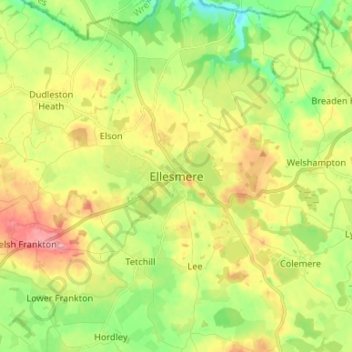
Name: Ellesmere topographic map, elevation, terrain.

Location: Ellesmere, Shropshire, England, SY12 0EQ, United Kingdom (52.86742 -2.93387 52.94742 -2.85387)

Average elevation: 94 m

Minimum elevation: 46 m

Maximum elevation: 155 m

Other topographic maps

Click on a map to view its topography, its elevation and its terrain.

Clungunford

United Kingdom > England > Shropshire

Clungunford lies at an elevation of between 130m and 145m above sea level.

Average elevation: 181 m

Badger Lake

United Kingdom > England > Shropshire > Woore

Average elevation: 130 m

Shrewsbury

United Kingdom > England > Shropshire > Shrewsbury

Shrewsbury is about 14 miles (23 km) west of Telford, 43 miles (69 km) west of Birmingham and the West Midlands Conurbation, and about 153 miles (246 km) north-west of the capital, London. More locally, the town is to the east of Welshpool, with Bridgnorth and Kidderminster to the south-east. The border with…

Average elevation: 69 m

Market Drayton

United Kingdom > England > Shropshire

Average elevation: 94 m

Gear up for your next adventure:

👖Convertible Hiking Pants - Zip-off legs to adapt to changing weather conditions
🧴Bear Spray Holster - Quick-access carry for essential Canadian wilderness safety
Lightweight Backpacking Tent - Compact tent for efficient hiking trips
🧦Hiking Liner Socks - Thin base layer to prevent friction and blisters
🧦Hiking Socks - Moisture-wicking and comfortable socks for long hikes

As an Amazon Associate, this site earns from qualifying purchases at no extra cost to you.