Geolocate

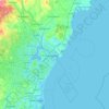
Hollis topographic map

Click on the map to display elevation.

About this map
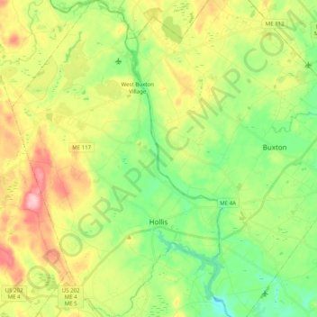
Name: Hollis topographic map, elevation, terrain.

Location: Hollis, York County, Maine, 04042, United States (43.56129 -70.68356 43.70445 -70.55117)

Average elevation: 76 m

Minimum elevation: 13 m

Maximum elevation: 173 m

Other topographic maps

Click on a map to view its topography, its elevation and its terrain.

Boon Island

United States > Maine > York County > York

Average elevation: 0 m

Lake Sherburne

United States > Maine > York County > Waterboro

Average elevation: 142 m

Wells Beach

United States > Maine > York County > Wells

Average elevation: 1 m

Jamaica Island

United States > Maine > York County > Kittery

Average elevation: 31 m

Parsons Beach

United States > Maine > York County > Kennebunk

Average elevation: 3 m

Crescent Beach

United States > Maine > York County > Kittery

Average elevation: 5 m

Rotary Park

United States > Maine > York County > Kennebunk > Kennebunk

Average elevation: 18 m

Mount Agamenticus

United States > Maine > York County > York

Average elevation: 92 m

Boon Island

United States > Maine > York County > York

Average elevation: 0 m

Mount Agamenticus

United States > Maine > York County > York

Average elevation: 92 m

Rotary Park

United States > Maine > York County > Kennebunk > Kennebunk

Average elevation: 18 m

Ogunquit Beach

United States > Maine > York County > Ogunquit

Average elevation: 11 m

Holdsworth Park

United States > Maine > York County > Sanford

Average elevation: 130 m

Gear up for your next adventure:

🔪Outdoor Multitool - Versatile tool for repairs and food prep in the wild
🛌Insulated Sleeping Pad - Critical thermal barrier between you and the cold ground
🥾Light Hiking Boots - Lightweight and comfortable boots for day hikes
🧦Merino Wool Socks - Moisture-wicking comfort for long-distance hiking
🧢Hiking Hat - Sun-protective and breathable hats for long treks

As an Amazon Associate, this site earns from qualifying purchases at no extra cost to you.