
Guaviare topographic map
Click on the map to display elevation.
About this map
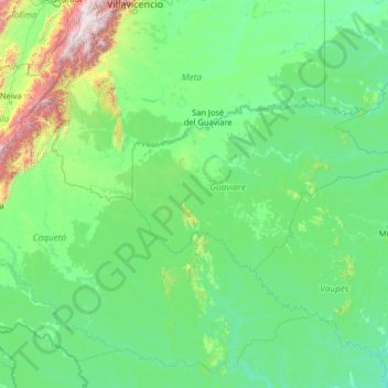
Name: Guaviare topographic map, elevation, terrain.
Location: Guaviare, RAP Amazonía, Colombia (-0.91056 -75.42029 4.28944 -70.22029)
Average elevation: 345 m
Minimum elevation: 83 m
Maximum elevation: 4,079 m
Other topographic maps
Click on a map to view its topography, its elevation and its terrain.
Bogota, Capital District
Bogotá is located in the southeastern part of the Bogotá savanna (Sabana de Bogotá) at an average altitude of 2,640 meters (8,660 ft) above sea level. The Bogotá savanna is popularly called "savannah" (sabana), but constitutes actually a high plateau in the Andes mountains, part of an extended region known…
Average elevation: 2,183 m
Medellín
Medellín has 16 comunas (districts), 5 corregimientos (townships), and 271 barrios (neighborhoods). The metropolitan area of Medellín lies within the Aburrá valley at an elevation of 1,500 meters (4,900 feet) above sea level and is bisected by the Medellín River (also called Porce), which flows northward.…
Average elevation: 1,882 m
Perimetro Urbano Pereira
Pereira, like many Colombian cities, has high-elevation areas with difficult access or flat or steep parts. The streets are laid out according to the elevation of the respective zones.
Average elevation: 1,486 m
Bucaramanga
Colombia > Santander > Bucaramanga
Bucaramanga is located on a plateau in the Cordillera Oriental of the Colombian Andes, and many residents occupy unstable lands descending steeply from the meseta. Westbound of it, the Rio de Oro Canyon is located at an altitude of 600 metres (2,000 ft) above sea level. Eastbound, the Andean Range rises up in…
Average elevation: 985 m
Ipiales
Ipiales is a city and Catholic bishopric in Nariño Department, southern Colombia, near the border with Ecuador. It is located at around 0°49′49″N 77°38′40″W / 0.83028°N 77.64444°W / 0.83028; -77.64444, with an elevation of about 2950 m. Ipiales is located on the high plateau called…
Average elevation: 2,902 m
Perímetro Urbano Cúcuta
Colombia > Norte de Santander > Cúcuta
The city is in the eastern part of the Department of North Santander, in the Cordillera Oriental, close to the border with Venezuela. The city's area is 110 square kilometres (42 square miles) and its elevation is 320 metres (1,050 feet) above sea level.
Average elevation: 314 m
Floridablanca
Floridablanca (Spanish pronunciation: [floˌɾiðaˈβlaŋka], locally also simply Florida) is a municipality in the department of Santander situated at an altitude of 925 metres (3,035 ft) in the Eastern Ranges of the Colombian Andes. It is part of the metropolitan area of the departmental capital…
Average elevation: 1,261 m
Ibagué
Ibagué features a tropical rainforest climate under the Köppen climate classification, albeit a relatively cooler version of the climate due to the high altitude. Although the city does experience noticeably drier conditions during and around the months of January and July, the city has no true dry season…
Average elevation: 1,905 m
Perímetro Urbano Neiva
Due to its location near the equator and its low altitude, the city has a hot annual average climate with daytime temperatures ranging from 88 to 95 degrees Fahrenheit. It is about 300 kilometers / 186.4 miles (about a five-hour drive) from the Colombian capital, Bogotá.
Average elevation: 469 m
Palmira
Palmira is located in southwestern Colombia, lying in the Cauca River valley. 3°31’48” north altitude and 76°81’13” longitude west of Greenwich. The city covers an area of 1,160 km2 (448 sq mi). The city lies at an elevation of 1,000 m (3,300 ft) above sea level.
Average elevation: 1,600 m
Olaya Herrera (Bocas de Satinga)
Colombia > Nariño > Olaya Herrera (Bocas de Satinga)
Average elevation: 13 m
Cali
Colombia > Valle del Cauca > Cali
Under Köppen's climate classification, Cali features a dry-summer tropical savanna climate (Köppen climate classification: As). The Western Mountain Range rises from an average of 2,000 m (6,562 ft) above sea level in the northern part of the city to approximately 4,000 m (13,123 ft) to the south. Because of…
Average elevation: 1,140 m