Geolocate

Oldhamstocks topographic map

Click on the map to display elevation.

About this map

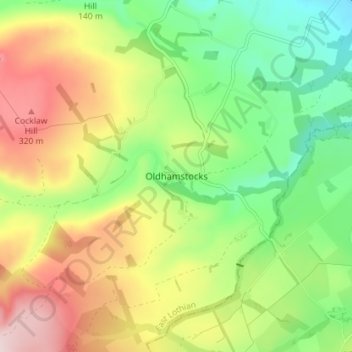
Name: Oldhamstocks topographic map, elevation, terrain.

Location: Oldhamstocks, East Lothian, Scotland, TD13 5XN, United Kingdom (55.90785 -2.43894 55.94785 -2.39894)

Average elevation: 182 m

Minimum elevation: 43 m

Maximum elevation: 368 m

Other topographic maps

Click on a map to view its topography, its elevation and its terrain.

Lammermuirs

United Kingdom > Scotland > East Lothian

Average elevation: 266 m

Coldale Wood

United Kingdom > Scotland > East Lothian

Average elevation: 65 m

Bass Rock

United Kingdom > Scotland > East Lothian

Average elevation: 0 m

Firth of Forth

United Kingdom > Scotland > East Lothian

Average elevation: 87 m

Gear up for your next adventure:

🧥Ultralight Puffy Jacket - Maximum warmth that packs down to the size of an orange
🧦Hiking Liner Socks - Thin base layer to prevent friction and blisters
💧Reusable Water Bottle - Durable water bottles for hydration on trails
🧢Sun Protection Cap - Breathable cap to protect from sun exposure
🥾Trail Hiking Boots - Supportive boots for rough trails

As an Amazon Associate, this site earns from qualifying purchases at no extra cost to you.