Geolocate

Fort Negley topographic map

Interactive map

Click on the map to display elevation.

About this map

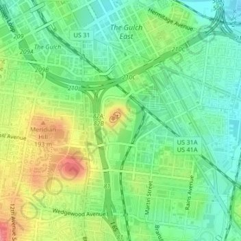
Name: Fort Negley topographic map, elevation, terrain.

Location: Fort Negley, Nashville, Davidson County, Middle Tennessee, Tennessee, United States (36.14208 -86.77645 36.14732 -86.77144)

Average elevation: 155 m

Minimum elevation: 123 m

Maximum elevation: 207 m

Other topographic maps

Click on a map to view its topography, its elevation and its terrain.

Bakertown

United States > Tennessee > Davidson County > Nashville

Average elevation: 166 m

Bellshire

United States > Tennessee > Davidson County > Nashville

Average elevation: 186 m

Bellshire

United States > Tennessee > Davidson County > Nashville

Average elevation: 186 m

Joelton

United States > Tennessee > Davidson County > Nashville

Average elevation: 236 m

Woodbine

United States > Tennessee > Davidson County > Nashville

Average elevation: 163 m

Antioch

United States > Tennessee > Davidson County > Nashville

Average elevation: 175 m

West

United States > Tennessee > Davidson County > Nashville

Average elevation: 235 m

Lickton

United States > Tennessee > Davidson County > Nashville

Average elevation: 201 m