
Make a donation
Gear up for your next adventure:
As an Amazon Associate, this site earns from qualifying purchases at no extra cost to you.
La Clotte topographic map
Click on the map to display elevation.
Make a donation
Gear up for your next adventure:
As an Amazon Associate, this site earns from qualifying purchases at no extra cost to you.
About this map
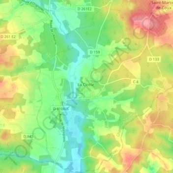
Name: La Clotte topographic map, elevation, terrain.
Average elevation: 50 m
Minimum elevation: 12 m
Maximum elevation: 101 m
Make a donation
Gear up for your next adventure:
As an Amazon Associate, this site earns from qualifying purchases at no extra cost to you.
Other topographic maps
Click on a map to view its topography, its elevation and its terrain.
Le Pont de Sablonceaux
France > Nouvelle-Aquitaine > Charente-Maritime > Sablonceaux > Saint-André-de-Sablonceaux
Average elevation: 22 m
Grand-Village
France > Nouvelle-Aquitaine > Charente-Maritime > Le Grand-Village-Plage
Average elevation: 4 m
Make a donation
Gear up for your next adventure:
As an Amazon Associate, this site earns from qualifying purchases at no extra cost to you.
Le Berceau
France > Nouvelle-Aquitaine > Charente-Maritime > Meschers-sur-Gironde
Average elevation: 14 m
Make a donation
Gear up for your next adventure:
As an Amazon Associate, this site earns from qualifying purchases at no extra cost to you.
Le Treuil Arnaudeau
France > Nouvelle-Aquitaine > Charente-Maritime > Saint-Médard-d'Aunis
Average elevation: 32 m
Make a donation
Gear up for your next adventure:
As an Amazon Associate, this site earns from qualifying purchases at no extra cost to you.
Make a donation
Gear up for your next adventure:
As an Amazon Associate, this site earns from qualifying purchases at no extra cost to you.
La Jagueneau
France > Nouvelle-Aquitaine > Charente-Maritime > Tonnay-Charente > La Jagueneau
Average elevation: 9 m
Le Marais Camus
France > Nouvelle-Aquitaine > Charente-Maritime > Saint-Pierre-d'Oléron
Average elevation: 4 m
Make a donation
Gear up for your next adventure:
As an Amazon Associate, this site earns from qualifying purchases at no extra cost to you.
Make a donation
Gear up for your next adventure:
As an Amazon Associate, this site earns from qualifying purchases at no extra cost to you.
Le Grand Moulin Est
France > Nouvelle-Aquitaine > Charente-Maritime > La Clotte
Average elevation: 44 m
Make a donation
Gear up for your next adventure:
As an Amazon Associate, this site earns from qualifying purchases at no extra cost to you.
Make a donation
Gear up for your next adventure:
As an Amazon Associate, this site earns from qualifying purchases at no extra cost to you.
Simoussais
France > Nouvelle-Aquitaine > Charente-Maritime > Saint-Pierre-d'Amilly
Average elevation: 25 m
Les Fontenelles
France > Nouvelle-Aquitaine > Charente-Maritime > Saint-Just-Luzac
Average elevation: 6 m
Make a donation
Gear up for your next adventure:
As an Amazon Associate, this site earns from qualifying purchases at no extra cost to you.
Foulerot
France > Nouvelle-Aquitaine > Charente-Maritime > Saint-Georges-d'Oléron
Average elevation: 3 m
Les Grands Champs
France > Nouvelle-Aquitaine > Charente-Maritime > Breuil-la-Réorte > Treuil Grand Vent
Average elevation: 44 m
Le Grand Village
France > Nouvelle-Aquitaine > Charente-Maritime > Chenac-Saint-Seurin-d'Uzet > Chenac
Average elevation: 25 m
Make a donation
Gear up for your next adventure:
As an Amazon Associate, this site earns from qualifying purchases at no extra cost to you.
Fief des Pinaudes
France > Nouvelle-Aquitaine > Charente-Maritime > La Rochelle
Average elevation: 6 m
La Maladrie
France > Nouvelle-Aquitaine > Charente-Maritime > Pont-l'Abbé-d'Arnoult
Average elevation: 23 m
Les Tourettes
France > Nouvelle-Aquitaine > Charente-Maritime > Saint-Médard-d'Aunis
Average elevation: 29 m
Make a donation
Gear up for your next adventure:
As an Amazon Associate, this site earns from qualifying purchases at no extra cost to you.
La Croix du Pouilloux
France > Nouvelle-Aquitaine > Charente-Maritime > Sainte-Lheurine
Average elevation: 60 m
Plage de Chef de Baie
France > Nouvelle-Aquitaine > Charente-Maritime > La Rochelle
Average elevation: 3 m
Le Puits Courant
France > Nouvelle-Aquitaine > Charente-Maritime > Allas-Bocage
Average elevation: 69 m
Make a donation
Gear up for your next adventure:
As an Amazon Associate, this site earns from qualifying purchases at no extra cost to you.
Saint-Gilles d'Oléron
France > Nouvelle-Aquitaine > Charente-Maritime > Saint-Pierre-d'Oléron
Average elevation: 7 m
La Pommeraie des Gaillards
France > Nouvelle-Aquitaine > Charente-Maritime > Port-d'Envaux
Average elevation: 26 m
Moulin de la Croix
France > Nouvelle-Aquitaine > Charente-Maritime > Saint-Pierre-d'Oléron
Average elevation: 6 m
Make a donation
Gear up for your next adventure:
As an Amazon Associate, this site earns from qualifying purchases at no extra cost to you.
Champservé le Haut
France > Nouvelle-Aquitaine > Charente-Maritime > Tonnay-Charente
Average elevation: 13 m
Champservé le Bas
France > Nouvelle-Aquitaine > Charente-Maritime > Tonnay-Charente
Average elevation: 11 m
Les Bagnes
France > Nouvelle-Aquitaine > Charente-Maritime > Saint-Pierre-d'Oléron
Average elevation: 5 m
Make a donation
Gear up for your next adventure:
As an Amazon Associate, this site earns from qualifying purchases at no extra cost to you.
La Sauzaie
France > Nouvelle-Aquitaine > Charente-Maritime > Dampierre-sur-Boutonne
Average elevation: 54 m
Les Biraudes
France > Nouvelle-Aquitaine > Charente-Maritime > Saint-Martin-de-Ré
Average elevation: 7 m
Make a donation
Gear up for your next adventure:
As an Amazon Associate, this site earns from qualifying purchases at no extra cost to you.
Le Puits d'Asnières
France > Nouvelle-Aquitaine > Charente-Maritime > Asnières-la-Giraud
Average elevation: 59 m
Le Breuil Malmaud
France > Nouvelle-Aquitaine > Charente-Maritime > Saint-Martin-de-Juillers
Average elevation: 65 m
Make a donation
Gear up for your next adventure:
As an Amazon Associate, this site earns from qualifying purchases at no extra cost to you.
Le Moulin de la Brande
France > Nouvelle-Aquitaine > Charente-Maritime > Aigrefeuille-d'Aunis
Average elevation: 21 m
Make a donation
Gear up for your next adventure:
As an Amazon Associate, this site earns from qualifying purchases at no extra cost to you.
La Fromagère
France > Nouvelle-Aquitaine > Charente-Maritime > Dompierre-sur-Mer
Average elevation: 21 m
Make a donation
Gear up for your next adventure:
As an Amazon Associate, this site earns from qualifying purchases at no extra cost to you.
Make a donation
Gear up for your next adventure:
As an Amazon Associate, this site earns from qualifying purchases at no extra cost to you.
Make a donation
Gear up for your next adventure:
As an Amazon Associate, this site earns from qualifying purchases at no extra cost to you.
Le Maurin
France > Nouvelle-Aquitaine > Charente-Maritime > Saint-Martin-d'Ary
Average elevation: 78 m
Make a donation
Gear up for your next adventure:
As an Amazon Associate, this site earns from qualifying purchases at no extra cost to you.
Bois des Épinettes
France > Nouvelle-Aquitaine > Charente-Maritime > Nieul-lès-Saintes > Touche-Marteau
Average elevation: 34 m
Make a donation
Gear up for your next adventure:
As an Amazon Associate, this site earns from qualifying purchases at no extra cost to you.
Château Milan
France > Nouvelle-Aquitaine > Charente-Maritime > Dompierre-sur-Mer
Average elevation: 25 m
Les Pibles
France > Nouvelle-Aquitaine > Charente-Maritime > Saint-Pierre-d'Oléron
Average elevation: 3 m
Make a donation
Gear up for your next adventure:
As an Amazon Associate, this site earns from qualifying purchases at no extra cost to you.
Make a donation
Gear up for your next adventure:
As an Amazon Associate, this site earns from qualifying purchases at no extra cost to you.
Saint-Nicolas
France > Nouvelle-Aquitaine > Charente-Maritime > Saint-Dizant-du-Gua
Average elevation: 14 m
Make a donation
Gear up for your next adventure:
As an Amazon Associate, this site earns from qualifying purchases at no extra cost to you.