Geolocate

Vélez topographic map

Click on the map to display elevation.

About this map

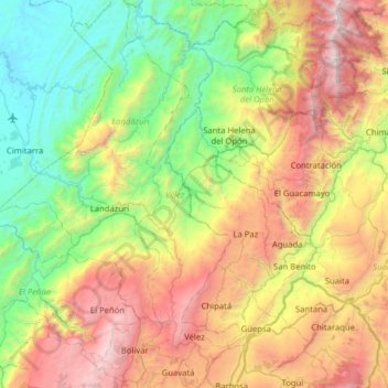
Name: Vélez topographic map, elevation, terrain.

Location: Vélez, Santander, Colombia (5.92868 -73.78825 6.55750 -73.59500)

Average elevation: 1,224 m

Minimum elevation: 99 m

Maximum elevation: 3,414 m

Other topographic maps

Click on a map to view its topography, its elevation and its terrain.

Giradot

Colombia > Santander > Chima

Average elevation: 1,500 m

Barrancabermeja

Colombia > Santander > Barrancabermeja

Average elevation: 82 m

Río Frío

Colombia > Santander > Floridablanca

Average elevation: 1,182 m

Barichara

Colombia > Santander > Barichara > Barichara

Average elevation: 1,196 m

Quebrada Larga

Colombia > Santander > Quebrada Larga

Average elevation: 1,918 m

Quebrada Larga

Colombia > Santander > Landázuri > Quebrada Larga

Average elevation: 615 m

Chucurí

Colombia > Santander > Barrancabermeja > Chucurí

Average elevation: 82 m

Las Palma

Colombia > Santander > Macaravita > Macaravita

Average elevation: 2,722 m

Cerro Caracol

Colombia > Santander > Concepción

Average elevation: 3,559 m

Gear up for your next adventure:

🔥Camping Stove - Portable stoves to cook outdoors with ease
🧴Outdoor Sunscreen - High SPF protection for high-altitude UV exposure
🧥Softshell Hiking Jacket - The perfect balance of wind protection and breathability
🪑Ultralight Camping Stool - Compact seating for rest stops during long hikes
🛌Down Sleeping Bag - Superior warmth-to-weight ratio for cold nights

As an Amazon Associate, this site earns from qualifying purchases at no extra cost to you.