Geolocate

Captina topographic map

Click on the map to display elevation.

About this map

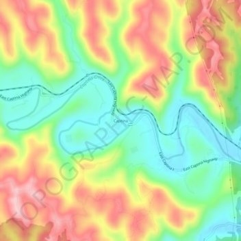
Name: Captina topographic map, elevation, terrain.

Location: Captina, Belmont County, Ohio, United States (39.86757 -80.89093 39.90757 -80.85093)

Average elevation: 289 m

Minimum elevation: 192 m

Maximum elevation: 403 m

Other topographic maps

Click on a map to view its topography, its elevation and its terrain.

Neffs

United States > Ohio > Belmont County > Neffs

Average elevation: 300 m

Morristown

United States > Ohio > Belmont County

Average elevation: 374 m

Flushing

United States > Ohio > Belmont County

Average elevation: 365 m

Holloway

United States > Ohio > Belmont County

Average elevation: 313 m

Brookside

United States > Ohio > Belmont County

Average elevation: 281 m

Bridgeport

United States > Ohio > Belmont County

Average elevation: 244 m

Bethesda

United States > Ohio > Belmont County

Average elevation: 376 m

Belmont

United States > Ohio > Belmont County

Average elevation: 361 m

Martins Ferry

United States > Ohio > Belmont County

Average elevation: 288 m

Piedmont Lake

United States > Ohio > Belmont County

Average elevation: 321 m

Yorkville

United States > Ohio > Belmont County

Average elevation: 256 m

Powhatan Point

United States > Ohio > Belmont County

Average elevation: 241 m

Shadyside

United States > Ohio > Belmont County

Average elevation: 245 m

Gear up for your next adventure:

🦯Trekking Poles - Reduced impact on joints for steep topographic climbs
🗺️Topographic Maps - Detailed maps to explore trails, mountains, and wilderness areas
🐕Hiking Dog Pack - Let your canine companion carry their own water and food
🧢Sun Hat - Wide-brim hat for sun protection
Camping Coffee Maker - Brew fresh coffee anywhere on the topographic map

As an Amazon Associate, this site earns from qualifying purchases at no extra cost to you.