
Make a donation
Gear up for your next adventure:
As an Amazon Associate, this site earns from qualifying purchases at no extra cost to you.
Luang Prabang topographic map
Click on the map to display elevation.
Make a donation
Gear up for your next adventure:
As an Amazon Associate, this site earns from qualifying purchases at no extra cost to you.
Luang Prabang
The 60,070 hectare Phou Louey Massif Important Bird Area (IBA) is in the Nam Et-Phou Louey National Biodiversity Conservation Area (NBCA). The IBA is in the provinces of Luang Prabang and Houaphanh. It sits at an elevation of 700–1,800 metres (2,300–5,900 ft). The habitat contains mixed deciduous forest, semi-evergreen forest, lower montane evergreen forest, upper montane evergreen forest, and secondary grassland. Notable avifauna include beautiful nuthatch Sitta formosa, Blyth's kingfisher Alcedo hercules, rufous-necked hornbill Aceros nipalensis, and yellow-vented warbler Phylloscopus cantator.
Make a donation
Gear up for your next adventure:
As an Amazon Associate, this site earns from qualifying purchases at no extra cost to you.
About this map
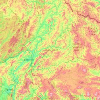
Name: Luang Prabang topographic map, elevation, terrain.
Location: Luang Prabang, Laos (19.04225 101.72238 21.13570 103.40047)
Average elevation: 910 m
Minimum elevation: 236 m
Maximum elevation: 2,481 m
Make a donation
Gear up for your next adventure:
As an Amazon Associate, this site earns from qualifying purchases at no extra cost to you.
Other topographic maps
Click on a map to view its topography, its elevation and its terrain.
Make a donation
Gear up for your next adventure:
As an Amazon Associate, this site earns from qualifying purchases at no extra cost to you.
B. Haysok
Laos > Vientiane Prefecture > Chanthabuly District > Vientiane Capital
Average elevation: 170 m
Make a donation
Gear up for your next adventure:
As an Amazon Associate, this site earns from qualifying purchases at no extra cost to you.
Make a donation
Gear up for your next adventure:
As an Amazon Associate, this site earns from qualifying purchases at no extra cost to you.
Saphangmo
Laos > Vientiane Prefecture > Xaysetha District > Vientiane Capital
Average elevation: 170 m
Make a donation
Gear up for your next adventure:
As an Amazon Associate, this site earns from qualifying purchases at no extra cost to you.
Donnokkhoum
Laos > Vientiane Prefecture > Sisattanak District > Vientiane Capital
Average elevation: 170 m
Phonsinouan
Laos > Vientiane Prefecture > Sisattanak District > Vientiane Capital
Average elevation: 170 m
Make a donation
Gear up for your next adventure:
As an Amazon Associate, this site earns from qualifying purchases at no extra cost to you.
Make a donation
Gear up for your next adventure:
As an Amazon Associate, this site earns from qualifying purchases at no extra cost to you.
Nongtaeng
Laos > Vientiane Prefecture > Sikhottabong District > Vientiane Capital
Average elevation: 174 m
Dongkhamxang
Laos > Vientiane Prefecture > Hadxayfong District > Vientiane Capital
Average elevation: 172 m
Make a donation
Gear up for your next adventure:
As an Amazon Associate, this site earns from qualifying purchases at no extra cost to you.
Nonghai
Laos > Vientiane Prefecture > Hadxayfong District > Vientiane Capital
Average elevation: 172 m
Muangvatha
Laos > Vientiane Prefecture > Sikhottabong District > Vientiane Capital
Average elevation: 169 m
Dognaxoyneua
Laos > Vientiane Prefecture > Sikhottabong District > Vientiane Capital
Average elevation: 169 m
Make a donation
Gear up for your next adventure:
As an Amazon Associate, this site earns from qualifying purchases at no extra cost to you.
ທົ່ງປົງ
Laos > Vientiane Prefecture > Sikhottabong District > Vientiane Capital
Average elevation: 174 m
Make a donation
Gear up for your next adventure:
As an Amazon Associate, this site earns from qualifying purchases at no extra cost to you.
Nongtha Marsh
Laos > Vientiane Prefecture > Chanthabuly District > Vientiane Capital > B. Nongthanua
Average elevation: 175 m
Don Koy
Laos > Vientiane Prefecture > Sisattanak District > Vientiane Capital
Average elevation: 169 m
Chommanytai
Laos > Vientiane Prefecture > Xaysetha District > Vientiane Capital
Average elevation: 172 m
Make a donation
Gear up for your next adventure:
As an Amazon Associate, this site earns from qualifying purchases at no extra cost to you.
Make a donation
Gear up for your next adventure:
As an Amazon Associate, this site earns from qualifying purchases at no extra cost to you.
Make a donation
Gear up for your next adventure:
As an Amazon Associate, this site earns from qualifying purchases at no extra cost to you.
Dongphosy
Laos > Vientiane Prefecture > Hadxayfong District > Vientiane Capital
Average elevation: 168 m
Make a donation
Gear up for your next adventure:
As an Amazon Associate, this site earns from qualifying purchases at no extra cost to you.
Make a donation
Gear up for your next adventure:
As an Amazon Associate, this site earns from qualifying purchases at no extra cost to you.
Make a donation
Gear up for your next adventure:
As an Amazon Associate, this site earns from qualifying purchases at no extra cost to you.
Make a donation
Gear up for your next adventure:
As an Amazon Associate, this site earns from qualifying purchases at no extra cost to you.
Make a donation
Gear up for your next adventure:
As an Amazon Associate, this site earns from qualifying purchases at no extra cost to you.
Make a donation
Gear up for your next adventure:
As an Amazon Associate, this site earns from qualifying purchases at no extra cost to you.
Thatlouangkang
Laos > Vientiane Prefecture > Xaysetha District > Vientiane Capital
Average elevation: 170 m
Make a donation
Gear up for your next adventure:
As an Amazon Associate, this site earns from qualifying purchases at no extra cost to you.
Make a donation
Gear up for your next adventure:
As an Amazon Associate, this site earns from qualifying purchases at no extra cost to you.
Xiangkhouang
Xiangkhouang province covers an area of 15,880 square kilometres (6,130 sq mi) and is mountainous. Apart from floodplains, the largest area of level land in the country is on the province's Xiangkhoang Plateau. The plateau is characterized by rolling hills and grassland whose elevation averages 1,300 metres…
Average elevation: 565 m
Make a donation
Gear up for your next adventure:
As an Amazon Associate, this site earns from qualifying purchases at no extra cost to you.
Make a donation
Gear up for your next adventure:
As an Amazon Associate, this site earns from qualifying purchases at no extra cost to you.
Make a donation
Gear up for your next adventure:
As an Amazon Associate, this site earns from qualifying purchases at no extra cost to you.
Sibounheuang
Laos > Vientiane Prefecture > Chanthabuly District > Sibounheuang
Average elevation: 171 m
Make a donation
Gear up for your next adventure:
As an Amazon Associate, this site earns from qualifying purchases at no extra cost to you.
Make a donation
Gear up for your next adventure:
As an Amazon Associate, this site earns from qualifying purchases at no extra cost to you.