Geolocate

VI. kerület topographic map

Interactive map

Click on the map to display elevation.

About this map

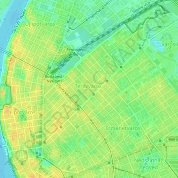
Name: VI. kerület topographic map, elevation, terrain.

Location: VI. kerület, Budapest, Hungría Central, Hungría (47.49755 19.05482 47.51878 19.08084)

Average elevation: 114 m

Minimum elevation: 100 m

Maximum elevation: 126 m

Other topographic maps

Click on a map to view its topography, its elevation and its terrain.

IV. kerület

Hungría > Budapest

IV. kerület, Budapest, Hungría Central, Hungría

Average elevation: 111 m

II. kerület

Hungría > Budapest

II. kerület, Budapest, Hungría Central, Hungría

Average elevation: 252 m

300 m

Hungría > Budapest

300 m, Nagytétény, XXII. kerület, Budapest, Hungría Central, 1224, Hungría

Average elevation: 182 m

V. kerület

Hungría > Budapest

V. kerület, Budapest, Hungría Central, Hungría

Average elevation: 122 m

Budapest

Hungría > Budapest

Budapest, Hungría Central, Hungría

Average elevation: 171 m

Istenhegy

Hungría > Budapest

Istenhegy, 12. kerület, Budapest, Hungría Central, 1125, Hungría

Average elevation: 258 m

Danubio

Hungría > Budapest

Danubio, Budapest, Hungría Central, 1036, Hungría

Average elevation: 114 m