
2nd district topographic map
Interactive map
Click on the map to display elevation.
About this map
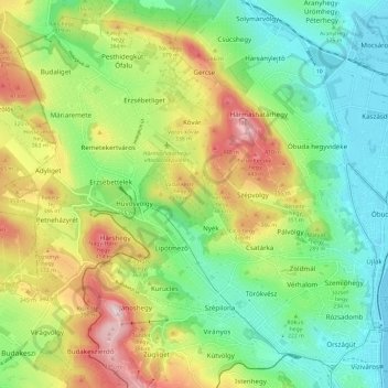
Name: 2nd district topographic map, elevation, terrain.
Location: 2nd district, Budapest, Central Hungary, Hungary (47.50607 18.92511 47.57891 19.04271)
Average elevation: 252 m
Minimum elevation: 100 m
Maximum elevation: 513 m
Other topographic maps
Click on a map to view its topography, its elevation and its terrain.
Óbudai-sziget
Óbudai-sziget, 3rd district, Budapest, Central Hungary, Hungary
Average elevation: 106 m
1st district
1st district, Budapest, Central Hungary, Hungary
Average elevation: 137 m
18th district
18th district, Budapest, Central Hungary, Hungary
Average elevation: 127 m
8th district
8th district, Budapest, Central Hungary, Hungary
Average elevation: 115 m
11th district
11th district, Budapest, Central Hungary, Hungary
Average elevation: 139 m
14th district
14th district, Budapest, Central Hungary, Hungary
Average elevation: 116 m
12th district
12th district, Budapest, Central Hungary, Hungary
Average elevation: 267 m
9th district
9th district, Budapest, Central Hungary, Hungary
Average elevation: 113 m
Hűvösvölgy
Hűvösvölgy, 2nd district, Budapest, Central Hungary, Hungary
Average elevation: 274 m
Kelenvölgy
Kelenvölgy, 11th district, Budapest, Central Hungary, 1514, Hungary
Average elevation: 120 m
János-hegy
János-hegy, Budapest, Central Hungary, 1021, Hungary
Average elevation: 343 m
Gellért Hill
Gellért Hill, Budapest, Central Hungary, 1114, Hungary
Average elevation: 126 m
Hármashatárhegy
Hármashatárhegy, 3rd district, Budapest, Central Hungary, Hungary
Average elevation: 291 m
Margaret Island
Margaret Island, Budapest, Central Hungary, 1007, Hungary
Average elevation: 115 m