

Peoa topographic map
Click on the map to display elevation.
About this map
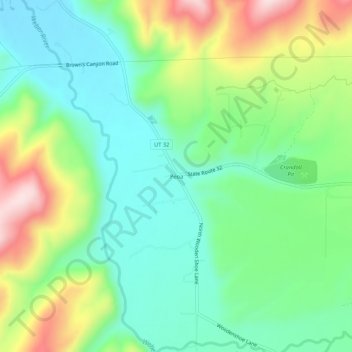
Name: Peoa topographic map, elevation, terrain.
Location: Peoa, Summit County, Utah, 84061, United States (40.70467 -111.36186 40.74467 -111.32186)
Average elevation: 1,966 m
Minimum elevation: 1,853 m
Maximum elevation: 2,190 m
Other topographic maps
Click on a map to view its topography, its elevation and its terrain.
Park City
United States > Utah > Summit County
In the summertime, many valley residents of the Wasatch Front visit the town to escape high temperatures. Park City is usually cooler than Salt Lake City as it lies mostly higher than 7,000 feet (2,100 m) above sea level, while Salt Lake City is situated at an elevation of about 4,300 feet (1,300 m).
Average elevation: 2,290 m
Park City
United States > Utah > Summit County
In the summertime, many valley residents of the Wasatch Front visit the town to escape high temperatures. Park City is usually cooler than Salt Lake City as it lies mostly higher than 7,000 feet (2,100 m) above sea level, while Salt Lake City is situated at an elevation of about 4,300 feet (1,300 m).
Average elevation: 2,290 m
Coalville
United States > Utah > Summit County
Coalville has a high-altitude, warm-summer humid continental climate (Köppen Dfb), characterized by extreme diurnal temperature ranges that range from extremely cold winter nights to hot afternoons in the summer. However, the high altitude and low humidity mean that mornings in the summer remain very cool,…
Average elevation: 1,825 m
Park City
United States > Utah > Summit County
In the summertime, many valley residents of the Wasatch Front visit the town to escape high temperatures. Park City is usually cooler than Salt Lake City as it lies mostly higher than 7,000 feet (2,100 m) above sea level, while Salt Lake City is situated at an elevation of about 4,300 feet (1,300 m).
Average elevation: 2,290 m
Oakley
United States > Utah > Summit County
Oakley is located 45 miles (72 km) east of Salt Lake City on SR-32, in the Kamas Valley. With an elevation of 6,500 feet (2,000 m), it is a gateway to the Uinta Mountains. Scenic route Weber Canyon Road follows the Weber River to its headwaters; it also follows the Smith and Morehouse Creek to its reservoir in…
Average elevation: 2,047 m
Park City
United States > Utah > Summit County
In the summertime, many valley residents of the Wasatch Front visit the town to escape high temperatures. Park City is usually cooler than Salt Lake City as it lies mostly higher than 7,000 feet (2,100 m) above sea level, while Salt Lake City is situated at an elevation of about 4,300 feet (1,300 m).
Average elevation: 2,290 m
Coalville
United States > Utah > Summit County
Coalville has a high-altitude, warm-summer humid continental climate (Köppen Dfb) that borders a subarctic climate (Dfc), characterized by extreme diurnal temperature ranges that range from extremely cold winter nights to hot afternoons in the summer. However, the high altitude and low humidity mean that…
Average elevation: 1,825 m
Park City
United States > Utah > Summit County
In the summertime, many valley residents of the Wasatch Front visit the town to escape high temperatures. Park City is usually cooler than Salt Lake City as it lies mostly higher than 7,000 feet (2,100 m) above sea level, while Salt Lake City is situated at an elevation of about 4,300 feet (1,300 m).
Average elevation: 2,290 m
Park City
United States > Utah > Summit County
In the summertime, many valley residents of the Wasatch Front visit the town to escape high temperatures. Park City is usually cooler than Salt Lake City as it lies mostly higher than 7,000 feet (2,100 m) above sea level, while Salt Lake City is situated at an elevation of about 4,300 feet (1,300 m).
Average elevation: 2,290 m
Coalville
United States > Utah > Summit County
Coalville has a high-altitude, warm-summer humid continental climate (Köppen Dfb), characterized by extreme diurnal temperature ranges that range from extremely cold winter nights to hot afternoons in the summer. However, the high altitude and low humidity mean that mornings in the summer remain very cool,…
Average elevation: 1,825 m
Park City
United States > Utah > Summit County
In the summertime, many valley residents of the Wasatch Front visit the town to escape high temperatures. Park City is usually cooler than Salt Lake City as it lies mostly higher than 7,000 feet (2,100 m) above sea level, while Salt Lake City is situated at an elevation of about 4,300 feet (1,300 m).
Average elevation: 2,290 m