
Make a donation
Gear up for your next adventure:
As an Amazon Associate, this site earns from qualifying purchases at no extra cost to you.
Fier County topographic map
Click on the map to display elevation.
Make a donation
Gear up for your next adventure:
As an Amazon Associate, this site earns from qualifying purchases at no extra cost to you.
About this map
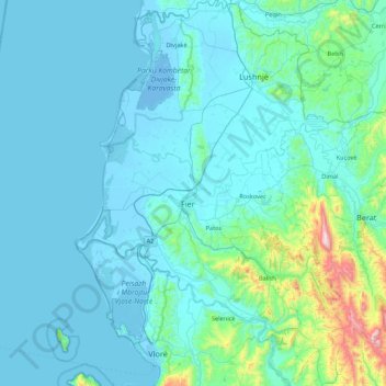
Name: Fier County topographic map, elevation, terrain.
Location: Fier County, Southern Albania, Albania (40.41540 19.31361 41.06925 19.92334)
Average elevation: 101 m
Minimum elevation: -7 m
Maximum elevation: 1,185 m
Make a donation
Gear up for your next adventure:
As an Amazon Associate, this site earns from qualifying purchases at no extra cost to you.
Other topographic maps
Click on a map to view its topography, its elevation and its terrain.
Make a donation
Gear up for your next adventure:
As an Amazon Associate, this site earns from qualifying purchases at no extra cost to you.
Gjirokastër Castle
Albania > Southern Albania > Gjirokastër County > Gjirokastra
Average elevation: 333 m
Make a donation
Gear up for your next adventure:
As an Amazon Associate, this site earns from qualifying purchases at no extra cost to you.
Tushemisht
Albania > Southern Albania > Korçë County
Tushemisht is a village in the Korçë County, in southeastern Albania, located on the shores of Lake Ohrid. It was part of the former Buçimas municipality. At the 2015 local government reform it became part of the municipality Pogradec. The village is very close to the border with Republic of North…
Average elevation: 740 m
Make a donation
Gear up for your next adventure:
As an Amazon Associate, this site earns from qualifying purchases at no extra cost to you.
Make a donation
Gear up for your next adventure:
As an Amazon Associate, this site earns from qualifying purchases at no extra cost to you.
Make a donation
Gear up for your next adventure:
As an Amazon Associate, this site earns from qualifying purchases at no extra cost to you.
Make a donation
Gear up for your next adventure:
As an Amazon Associate, this site earns from qualifying purchases at no extra cost to you.
Llogara National Park
Albania > Southern Albania > Vlorë County > Orikum
Phytogeographically, the park falls within the Illyrian deciduous forests terrestrial ecoregion of the Palearctic Mediterranean forests, woodlands, and scrub biome. Its flora is diverse and characterised with high endemism, due to the combination of southern geographic latitude and high altitude variation. The…
Average elevation: 1,024 m
Make a donation
Gear up for your next adventure:
As an Amazon Associate, this site earns from qualifying purchases at no extra cost to you.
Make a donation
Gear up for your next adventure:
As an Amazon Associate, this site earns from qualifying purchases at no extra cost to you.
Make a donation
Gear up for your next adventure:
As an Amazon Associate, this site earns from qualifying purchases at no extra cost to you.
Kuç i Zi
Albania > Southern Albania > Korçë County > Bashkia Korçë > Kuç i Zi
Average elevation: 986 m
Make a donation
Gear up for your next adventure:
As an Amazon Associate, this site earns from qualifying purchases at no extra cost to you.
Zvarisht
Albania > Southern Albania > Korçë County > Bashkia Maliq > Zvarisht
Average elevation: 959 m