
Make a donation
Gear up for your next adventure:
As an Amazon Associate, this site earns from qualifying purchases at no extra cost to you.
Tragjas topographic map
Click on the map to display elevation.
Make a donation
Gear up for your next adventure:
As an Amazon Associate, this site earns from qualifying purchases at no extra cost to you.
About this map
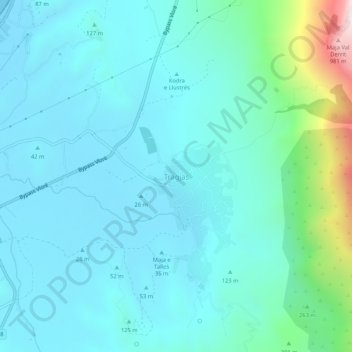
Name: Tragjas topographic map, elevation, terrain.
Average elevation: 160 m
Minimum elevation: -3 m
Maximum elevation: 1,047 m
Make a donation
Gear up for your next adventure:
As an Amazon Associate, this site earns from qualifying purchases at no extra cost to you.
Other topographic maps
Click on a map to view its topography, its elevation and its terrain.
Llogara National Park
Albania > Southern Albania > Vlorë County > Orikum
Phytogeographically, the park falls within the Illyrian deciduous forests terrestrial ecoregion of the Palearctic Mediterranean forests, woodlands, and scrub biome. Its flora is diverse and characterised with high endemism, due to the combination of southern geographic latitude and high altitude variation. The…
Average elevation: 1,024 m