
Make a donation
Gear up for your next adventure:
As an Amazon Associate, this site earns from qualifying purchases at no extra cost to you.
Dhërmi topographic map
Click on the map to display elevation.
Make a donation
Gear up for your next adventure:
As an Amazon Associate, this site earns from qualifying purchases at no extra cost to you.
Dhërmi
Dhërmi (Albanian definite form: Dhërmiu; Greek: Δρυμάδες, Drymádes) is a village in Vlorë County, Albania. It is part of the municipality of Himarë. The village lies 42 kilometers south of the city of Vlorë and 69 kilometers north of the southern city of Sarandë. It is built on a slope of the Ceraunian Mountains at approximately 200 meters in altitude, and comprises three neighborhoods: Gjilek, Kondraq, Kallami, and Dhërmi itself. The mountains descend to the southwest into the Ionian coast and Corfu in the distance to the south. Nearby is the village of Palasë. The local inhabitants of Dhërmi are ethnic Greeks that mainly speak a variant of the Greek Himariote dialect, and partly the Tosk Albanian dialect. During the last decade, the coastal area has seen a boom in the construction of accommodation facilities, such as wooden villa complexes.
Make a donation
Gear up for your next adventure:
As an Amazon Associate, this site earns from qualifying purchases at no extra cost to you.
About this map
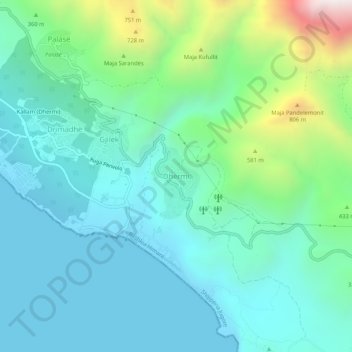
Name: Dhërmi topographic map, elevation, terrain.
Average elevation: 265 m
Minimum elevation: -2 m
Maximum elevation: 1,231 m
Make a donation
Gear up for your next adventure:
As an Amazon Associate, this site earns from qualifying purchases at no extra cost to you.