
Make a donation
Gear up for your next adventure:
As an Amazon Associate, this site earns from qualifying purchases at no extra cost to you.
Bangar topographic map
Click on the map to display elevation.
Make a donation
Gear up for your next adventure:
As an Amazon Associate, this site earns from qualifying purchases at no extra cost to you.
About this map
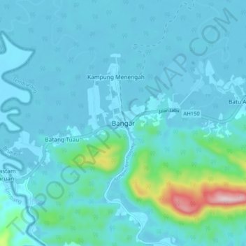
Name: Bangar topographic map, elevation, terrain.
Location: Bangar, Temburong District, Brunei (4.66765 115.03244 4.74765 115.11244)
Average elevation: 42 m
Minimum elevation: -1 m
Maximum elevation: 410 m
Make a donation
Gear up for your next adventure:
As an Amazon Associate, this site earns from qualifying purchases at no extra cost to you.
Other topographic maps
Click on a map to view its topography, its elevation and its terrain.
Belait District
The South China Sea borders Belait District to the north, Tutong District to the northeast, and Sarawak, Malaysia to the west and south. The district's lowlands are steep and below an elevation of 91 metres (299 ft). Areas along the shore, which are mostly characterised by marshy plains with slender alluvial…
Average elevation: 45 m
Make a donation
Gear up for your next adventure:
As an Amazon Associate, this site earns from qualifying purchases at no extra cost to you.
Make a donation
Gear up for your next adventure:
As an Amazon Associate, this site earns from qualifying purchases at no extra cost to you.
Make a donation
Gear up for your next adventure:
As an Amazon Associate, this site earns from qualifying purchases at no extra cost to you.