Geolocate

Triacastela topographic map

Click on the map to display elevation.

About this map

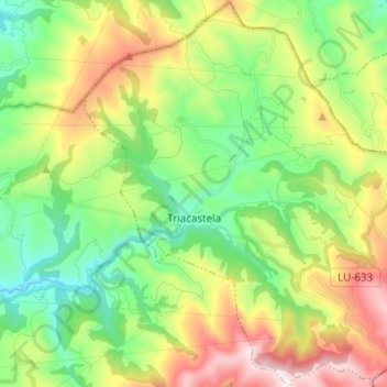
Name: Triacastela topographic map, elevation, terrain.

Location: Triacastela, Sarria, Lugo, Galicia, Spain (42.71679 -7.27489 42.80742 -7.16433)

Average elevation: 892 m

Minimum elevation: 566 m

Maximum elevation: 1,461 m

Other topographic maps

Click on a map to view its topography, its elevation and its terrain.

Lavandeira

Spain > Galicia > Sarria > Sarria

Average elevation: 636 m

Airexe

Spain > Galicia > Sarria > Sarria

Average elevation: 642 m

Rubial

Spain > Galicia > Sarria > Sarria

Average elevation: 487 m

Abadengo

Spain > Galicia > Sarria > O Incio

Average elevation: 655 m

Río

Spain > Galicia > Sarria

Average elevation: 803 m

Gear up for your next adventure:

🧭GPS Tracker - Track your location in remote areas safely
🧭GPS Outdoor Watch - Smart watch for navigation and fitness tracking in nature
🔦UV Flashlight - Detect minerals or specific insects in the dark
❄️Traction Ice Cleats - Slip-on spikes for icy trails and winter hiking
🧢Beanie Hat - Keep your head warm in cold weather

As an Amazon Associate, this site earns from qualifying purchases at no extra cost to you.