Geolocate

Abadengo topographic map

Click on the map to display elevation.

About this map

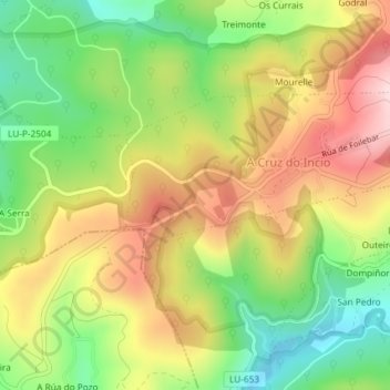
Name: Abadengo topographic map, elevation, terrain.

Location: Abadengo, O Incio, Sarria, Lugo, Galicia, 27345, Spain (42.64439 -7.38224 42.66439 -7.36224)

Average elevation: 655 m

Minimum elevation: 504 m

Maximum elevation: 819 m

Gear up for your next adventure:

🧣Merino Neck Gaiter - Protects against wind, sun, and cold at high altitudes
🪑Insulated Seat Pad - Protect your seat from cold rocks and wet logs
Camping Essentials - All-in-one gear for a comfortable camping trip
🧢Sun Protection Cap - Breathable cap to protect from sun exposure
💧Hydration Bladder - Hands-free hydration solution for long treks

As an Amazon Associate, this site earns from qualifying purchases at no extra cost to you.